Sprowston History
  • Home
  • Sprowston Road Index
    • Roads A >
      • Aiken Close
      • Alford Grove
      • Allens Avenue
      • Amos Bacon Close
      • Aslake Close
      • Avian Way
      • Avocet Rise
    • Roads B >
      • Barkers Lane
      • Blackwell Avenue
      • Blenhiem Road
      • Blithemeadow Drive
      • Blue Boar Lane
      • Breck Road
    • Roads C >
      • Cannerby Lane
      • Cecil Gowing Court
      • Cere Road
      • Chartwell Road
      • Chenery Drive
      • Church Green
      • Colindeep Lane
      • Constitution Hill
      • Corbet Avenue
      • Cozens Hardy Road
      • Creance Road
      • Cromwell Road
    • Roads D >
      • Dixons Fold
      • Dovedales
    • Roads E >
      • Edwards Road
    • Roads F >
      • Falcoln Road West
    • Roads G >
      • Glenburn Avenue
      • Goshawk Mews
    • Roads H >
      • Hammond Way
      • Harrisons Drive
      • Holly Bank
      • Hornbeam Close
    • Roads L >
      • Lambert Road
      • Linacre Avenue
      • Lone Barn Road
      • Lusher's Loke
    • Roads M >
      • Mallard Way
      • Merlin Avenue
      • Millwrights Way
      • Mousehold Lane
    • Roads N >
      • Neville Road
      • North Walsham Road
    • Roads P >
      • Parkland Road
      • Pinetrees Road
    • Roads R >
      • Recreation Ground Road
      • Rosemary Road
      • Roundtree Way
    • Roads S >
      • Salhouse Road
      • School Lane
      • Shipfield
      • Sparhawk Avenue
      • Sprowston Road
      • St Georges Loke
      • Stonehouse Road
    • Roads T >
      • Tills Road
      • Tills Close
      • Tusting Close
    • Roads V >
      • Varvel Avenue
    • Roads W >
      • White Woman Lane
      • Wilks Farm Drive
      • Woodside Road
      • Wroxham Road
  • Timeline
  • Other Areas
    • Other Roads A >
      • Airedale Close
      • All Saints Green
      • Amsterdam Way, Hellesdon
      • Angel Road
      • Anglia Square
      • Aylsham Road, Banningham
      • Aylsham Road, Norwich
    • Other Roads B >
      • Bacton Road, North Walsham
      • Back Of The Inns, Norwich
      • Barnard Road, Bowthorpe
      • Barrack Street, Norwich
      • Baxter Court, Norwich
      • Beach Road, Hemsby
      • Bedford Street, Norwich
      • Bell Road, Norwich
      • Bessemer Road, Norwich
      • Ber Street
      • Bethel Street
      • Borrowdale Drive
      • Botolph Street, Norwich
      • Boundary Road, Hellesdon
      • Bowthorpe Road
      • Branford Road
      • Bridge Road, Potter Heigham
      • Britannia Rd
      • Bull Close
      • Burma Road, Old Catton
      • ​Bussey Road, Fiddlewood
      • Buxton Road, Spixworth
    • Other Roads C >
      • Cabbell Road, Cromer
      • California Road, California
      • Calvert Street, Norwich
      • Carrow Road
      • Castle Meadow, Norwich
      • Castle Gardens, Norwich
      • Castle Street, Norwich
      • Castle Street, Wroxham
      • Catton Chase
      • Catton Grove Road
      • Cambridge Street, Norwich
      • Chapel Road, Roughton
      • Chapelfield Road
      • Charing Cross
      • Church Street, Cromer
      • Church Plain, Great Yarmouth
      • Church Road, Hoveton
      • Church Road, Upton
      • Churchill Road, Great Yarmouth
      • Clancy Road
      • Coast Road, Bacton
      • Concorde Road
      • Connaught Road
      • Cowgate
      • Cozens Road
      • Cremorne Lane
      • Cromer Road, Hellesdon
      • Cromer Road, Mundesley
      • Cromer Road, West Runton
    • Other Roads D >
      • Dales Loke, Thorpe St Andrew
      • Daniels Road, Norwich
      • Davey Place
      • Denmark Road
      • Dereham Road, Norwich
      • Diamond Road, Norwich
      • Dog Lane, Horsford
      • Drayton High Road
      • Drayton High Street, Drayton
      • Drayton Road, Mile Cross
      • Duke Street, Norwich
      • Dussindale Drive
    • Other Roads E >
      • Eade Road
      • Earlham Road, Norwich
      • Edwards Street, Norwich
      • Esdelle Street, Norwich
      • Eversley Road
    • Other Roads F >
      • Farmers Avenue
      • Fifers Lane
      • Furze Road, Thorpe St Andrew
      • Fye Bridge Street
    • Other Roads G >
      • Garden Street, Cromer
      • Gentlemen's Walk, Norwich
      • Golding Place
      • Grammar School Road, North Walsham
      • Guardian Road
      • Guildhall Hill
      • Gurney Road
    • Other Roads H >
      • Halls Corner, Hevingham
      • Harvey Lane
      • Havers Road
      • Haymarket, Norwich
      • Heartsease Lane
      • Heigham Street
      • Hemming Way, Norwich
      • Henby Way, Thorpe St Andrew
      • High Street, Coltishall
      • Hillcrest Road
      • High Street, Cromer
      • High Street, Mundesley
      • Holt Road, Cromer
      • High Street, Overstrand
      • Hooker Road, Heartsease
      • Horning Road, Hoveton
      • Holt Road, Hellesdon
      • Holt Road, Horsford
      • Honeycombe Road, Salhouse
      • Hurricane Way
    • Other Roads I >
      • Ipswich Road
    • Other Roads J
    • Other Roads K >
      • Ketts Hill
      • King Street, Norwich
    • Other Roads L >
      • Laundry Lane, Thorpe St Andrew
      • Lodge Lane, Old Catton
      • London Street, Norwich
      • Lower Goat Lane
      • Lower Street, Salhouse
    • Other Roads M >
      • Magdalen Road
      • Magdalen Street
      • Manor Road, Newton St Faith
      • Market Gate Shopping Centre
      • Market Place, Aylsham
      • Market Place, Great Yarmouth
      • Market Street, North Walsham
      • Marine Parade, Great Yarmouth
      • Marryat Road
      • Middlebrook Way, Cromer
      • Mill Road, Cromer
      • Mill Road, Salhouse
      • Millenium Plain, Norwich
      • Millgate, Trowse
      • Mile Cross Lane
      • Mile Cross Road
      • Millers Lane
    • Other Roads N >
      • Nelson Street, Norwich
      • New Road, North Walsham
      • North Walsham Road, Beeston St Andrew
      • North Walsham Road, Trunch
      • Norwich Research Park
      • Norwich Road, Aylsham
      • Norwich Road, Horsham St Faith
      • Norwich Road, Hoveton
      • Norwich Road, Marsham
      • Newport Road, Newport
      • Norwich Road, North Walsham
      • Northumberland Street, Norwich
      • Norwich Road, Wroxham
    • Other Roads O >
      • Oak Street, Norwich
      • Old Road, Acle
      • Old Library Mews
      • Orford Hill, Norwich
      • Orford Place, Norwich
    • Other Roads P >
      • Park Avenue, Scottow
      • Philadelphia Lane
      • Plumstead Road, Norwich
      • Plumstead Road, Thorpe End
      • Plumstead Road East
      • Pottergate
      • Pound Lane, Thorpe St Andrew
      • Prince Of Wales Road, Norwich
      • Priory Plain, Great Yarmouth
    • Other Roads Q >
      • Quebec Road, Norwich
      • Queens Road
    • Other Roads R >
      • Rampant Horse Street Norwich
      • Regent Road, Great Yarmouth
      • Reepham Road, Hellesdon
      • Riverside Centre, Hoveton
      • Riverside Road, Norwich
      • Rosary Road
      • Rose Lane, Norwich
      • Roundtree Close
      • Rouen Road
      • Runton Road, Cromer
    • Other Roads S >
      • Salhouse Road, Rackheath
      • Sae View Road, Hemsby
      • Silver Street, Norwich
      • South Hill Road, Thorpe St Andrew
      • South Market Road, Great Yarmouth
      • Southwell Road, Horsham St Faith
      • Spar Road, Norwich
      • Spixworth Road, Old Catton
      • St Augustines Street
      • St Benedict's Street, Norwich
      • St Faiths Road, Old Catton
      • St Giles Street
      • St Leonards Road
      • St Nicholas Road, Great Yarmouth
      • St Stephens Road
      • St Stephens Street
      • St Thomas Road, Hemsby
      • Stalham Road, Hoveton
      • Station Road, Hoveton
      • Station Road, West Runton
      • Surrey Street, Norwich
      • Swan Lane
    • Other Roads T >
      • The Green, Martham
      • The Paddocks, Old Catton
      • The Street, Brundall
      • The Street, Hemsby
      • Thorpe Avenue
      • Thorpe Road, Norwich
      • Thunder Lane, Thorpe St Andrew
      • Timberhill
      • Tombland
    • Other Roads U >
      • Unthank Road
    • Other Roads V >
      • Vulcan Road North / South
    • Other Roads W >
      • Waterloo Road
      • Watling Road, Heartsease
      • West End Street, Norwich
      • West Street, Cromer
      • Westlegate, Norwich
      • Westwick Street, Norwich
      • Weston Hall Road
      • Whiffler Road
      • White Lion Street, Norwich
      • Woodcock Road
      • Woodham Leas
      • Wroxham Road, Rackheath
    • Other Roads X
    • Other Roads Y >
      • Yarmouth Road, Caister On Sea
      • Yarmouth Road, North Walsham
      • Yarrmouth Road, Thorpe St Andrew
    • Other Roads Z
  • Links & Local Books
  • Credits
  • Contact Me
  • Salhouse Road
  • Hemsby - List of old shops and arcades
  • Egyptian Road
  • Lollard Road
  • Station Road, Coltishall
  • Whimpwell Green, Happisburgh
  • North Walsham Road, Scottow

Station Road, Hoveton

Clearview - Station Road, Hoveton
Used to be Norwich Building Society and then Norwich & Peterborough Building Society.
Capron & Hellliwell
Used to be Nat West bank.
Picture
Credit Angus Reid
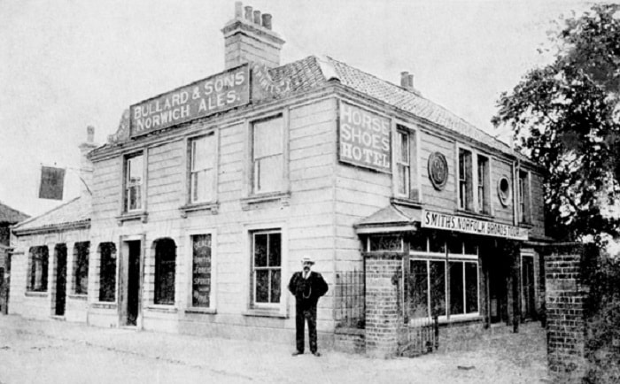
​Pictured below is the original Horseshoes Hotel in Hoveton pictured c1900. The sign on the end of the building advertises “Smiths Norfolk Broads Tour” and the gentleman standing in front of the hotel is presumably George Smith, who was the licensee of the hotel at this time. George and his sons ran a small fleet of passenger launches here and eventually began to expand into the holiday hire market with cabin yachts and eventually motor cruisers. His “Broads Tours” business moved further upstream near the railway bridge and was eventually sold to Charles Hannaford in the mid 1930s who expanded the fleet and business further. The Broads Tours name survives to this day at Wroxham.

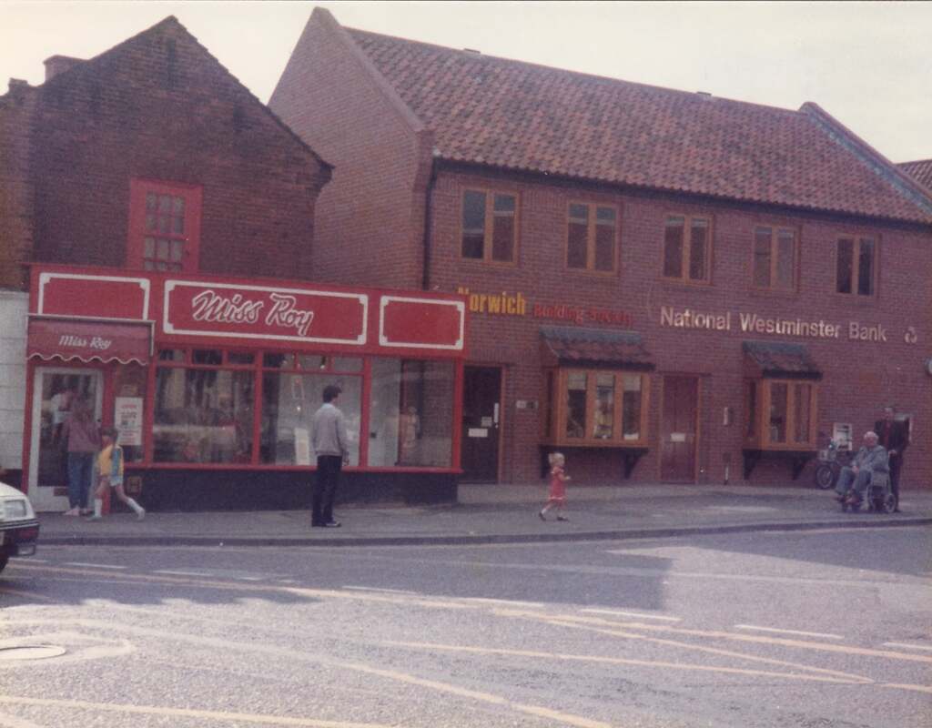
This building was demolished and a new pub was built which is the boarded up building next to Reads Pharmacy. It had 2 bars and discos and a games room and was a lively place to goto. It later changed its name to The Waterfront. 


Picture
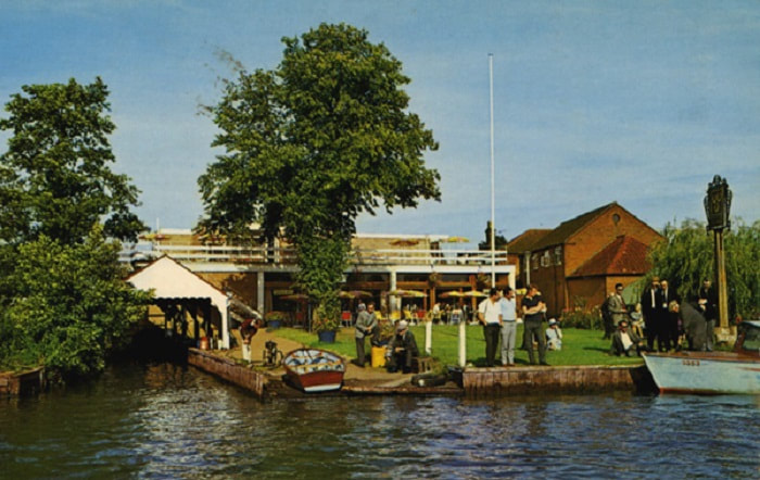
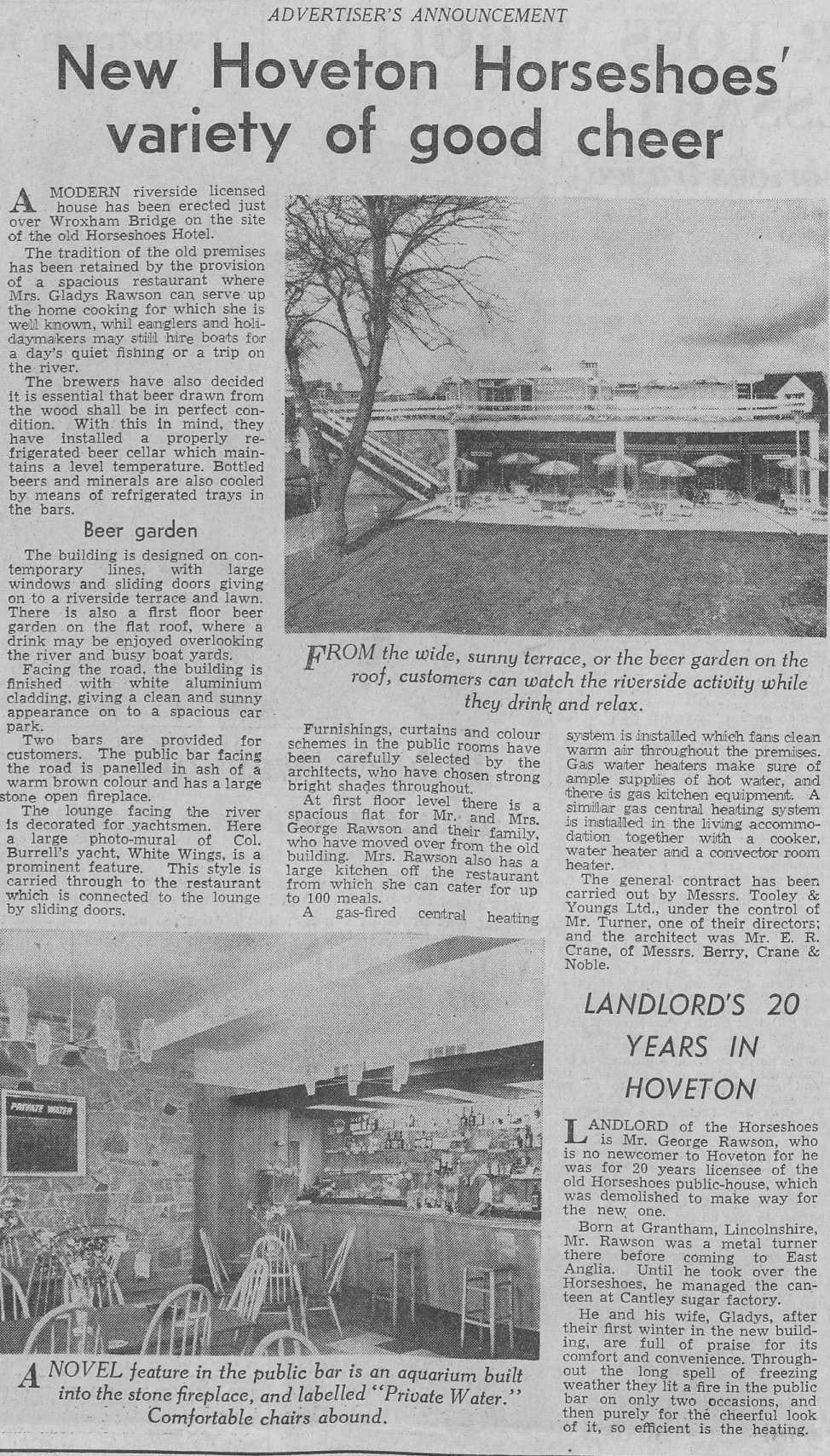
​The Three Horseshoes at Hoveton/Wroxham, pictured in the late 1960s. The Horseshoes Hotel seen earlier amongst this collection had been heavily altered c1900 and a more substantial brick building replaced the original wooden cladding. In 1961, the pub underwent further building work which included the balcony area seen above. The Horseshoes is currently closed and has been boarded up.
Picture

Picture
Powered by Create your own unique website with customizable templates.