Sprowston History
  • Home
  • Sprowston Road Index
    • Roads A >
      • Aiken Close
      • Alford Grove
      • Allens Avenue
      • Amos Bacon Close
      • Aslake Close
      • Atlantic Avenue
      • Avian Way
      • Avocet Rise
    • Roads B >
      • Barkers Lane
      • Blackwell Avenue
      • Blenhiem Road
      • Blithemeadow Drive
      • Blue Boar Lane
      • Breck Road
    • Roads C >
      • Cannerby Lane
      • Cecil Gowing Court
      • Cere Road
      • Chartwell Road
      • Chenery Drive
      • Church Green
      • Colindeep Lane
      • Constitution Hill
      • Corbet Avenue
      • Cozens Hardy Road
      • Creance Road
      • Cromwell Road
    • Roads D >
      • Dixons Fold
      • Dovedales
    • Roads E >
      • Edwards Road
    • Roads F >
      • Falcoln Road West
    • Roads G >
      • Glenburn Avenue
      • Goshawk Mews
    • Roads H >
      • Hammond Way
      • Harrisons Drive
      • Holly Bank
      • Hornbeam Close
    • Roads L >
      • Lambert Road
      • Linacre Avenue
      • Lone Barn Road
      • Lusher's Loke
    • Roads M >
      • Mallard Way
      • Merlin Avenue
      • Millwrights Way
      • Mousehold Lane
    • Roads N >
      • Neville Road
      • North Walsham Road
    • Roads P >
      • Parkland Road
      • Pinetrees Road
    • Roads R >
      • Recreation Ground Road
      • Rosemary Road
      • Roundtree Way
    • Roads S >
      • Salhouse Road
      • School Lane
      • Shipfield
      • Sparhawk Avenue
      • Sprowston Road
      • St Georges Loke
      • Stonehouse Road
    • Roads T >
      • Tills Road
      • Tills Close
      • Tusting Close
    • Roads V >
      • Varvel Avenue
    • Roads W >
      • White Woman Lane
      • Wilks Farm Drive
      • Woodside Road
      • Wroxham Road
  • Timeline
  • Other Areas
    • Other Roads A >
      • Airedale Close
      • All Saints Green
      • Amsterdam Way, Hellesdon
      • Anchor Street, Norwich
      • Angel Road
      • Anglia Square
      • Ardney Rise
      • Aylsham Road, Banningham
      • Aylsham Road, Norwich
    • Other Roads B >
      • Bacton Road, North Walsham
      • Back Of The Inns, Norwich
      • Barber Place
      • Barnard Road, Bowthorpe
      • Barrack Street, Norwich
      • Baxter Court, Norwich
      • Beach Road, Hemsby
      • Beach Road, Mundesley
      • Beach Road, Sheringham
      • Bedford Street, Norwich
      • Bell Road, Norwich
      • Bessemer Road, Norwich
      • Beeston Road, Sheringham
      • Ber Street
      • Bethel Street
      • Bishop Bridge Road
      • Borrowdale Drive
      • Botolph Street, Norwich
      • Boundary Road, Hellesdon
      • Bowers Avenue
      • Bowthorpe Road
      • Branford Road
      • Bridge Road, Potter Heigham
      • Britannia Rd
      • Bull Close
      • Bull Close Road
      • Burma Road, Old Catton
      • ​Bussey Road, Fiddlewood
      • Buxton Road, Spixworth
    • Other Roads C >
      • Cabbell Road, Cromer
      • California Road, California
      • Calvert Street, Norwich
      • Cambridge Street, Norwich
      • Carrow Hill
      • Carrow Road
      • Castle Meadow, Norwich
      • Castle Gardens, Norwich
      • Castle Street, Norwich
      • Castle Street, Wroxham
      • Cattle Market Street
      • Catton Chase
      • Catton Grove Road
      • Cedar Road
      • Chapel Road, Roughton
      • Chapelfield Road
      • Charing Cross
      • Church Street, Cromer
      • Church Street, Old Catton
      • Church Plain, Great Yarmouth
      • Church Road, Bacton
      • Church Road, Hoveton
      • Church Road, Upton
      • Church Street, Sheringham
      • Churchill Road, Great Yarmouth
      • Clancy Road
      • Coast Road, Bacton
      • Concorde Road
      • Connaught Road
      • Cowgate
      • Cozens Road
      • Cremorne Lane
      • Cromer Road, Aylsham
      • Cromer Road, Hellesdon
      • Cromer Road, Hevingham
      • Cromer Road, Mundesley
      • Cromer Road, Sheringham
      • Cromer Road, West Runton
      • Cucumber Lane, Brundall
    • Other Roads D >
      • Dales Loke, Thorpe St Andrew
      • Daniels Road, Norwich
      • Davey Place
      • Denmark Road
      • Dereham Road, Norwich
      • Diamond Road, Norwich
      • Dog Lane, Horsford
      • Dove Street, Norwich
      • Drayton High Road
      • Drayton High Street, Drayton
      • Drayton Road, Mile Cross
      • Duke Street, Norwich
      • Dussindale Drive
    • Other Roads E >
      • Eade Road
      • Earlham Road, Norwich
      • Edwards Street, Norwich
      • Egyptian Road
      • Esdelle Street, Norwich
      • Eversley Road
      • Exchange Street, Norwich
    • Other Roads F >
      • Farmers Avenue
      • Fifers Lane
      • Fishers Lane, Norwich
      • Furze Road, Thorpe St Andrew
      • Fye Bridge Street
    • Other Roads G >
      • Garden Street, Cromer
      • Garrick Green, Norwich
      • Gentlemen's Walk, Norwich
      • Gertrude Road, Norwich
      • Golden Ball Street
      • Golding Place
      • Grammar School Road, North Walsham
      • Grapes Hill
      • Greenborough Road
      • Guardian Road
      • Guildhall Hill
      • Gurney Road
    • Other Roads H >
      • Halls Corner, Hevingham
      • Harvey Lane
      • Havers Road
      • Haymarket, Norwich
      • Heath Road, Norwich
      • Heartsease Lane
      • Heigham Street
      • Hemming Way, Norwich
      • Henby Way, Thorpe St Andrew
      • High Street, Coltishall
      • Hillcrest Road
      • High Street, Cromer
      • High Street, Mundesley
      • High Street, Overstrand
      • High Street, Stalham
      • Holt Road, Cromer
      • Hooker Road, Heartsease
      • Horning Road, Hoveton
      • Holt Road, Hellesdon
      • Holt Road, Horsford
      • Honeycombe Road, Salhouse
      • Hurricane Way
    • Other Roads I >
      • Ingham Road, Lessingham
      • Ipswich Road
    • Other Roads J >
      • Jolly Gardeners Court, Norwich
    • Other Roads K >
      • Kerrison Road
      • Ketts Hill
      • King Street, Norwich
      • Kingsley Road, Norwich
    • Other Roads L >
      • Ladysmith Road, Norwich
      • Larkman Lane
      • Lawrence Street, Norwich
      • Lawson Road, Norwich
      • Laundry Lane, Thorpe St Andrew
      • Laundry Loke, North Walsham
      • Leopold Road
      • Lodge Lane, Old Catton
      • Lollard Road
      • London Street, Norwich
      • Lovett Close
      • Low Road, Norwich
      • Lower Goat Lane
      • Lower Street, Horning
      • Lower Street, Salhouse
    • Other Roads M >
      • Magdalen Road
      • Magdalen Street
      • Magpie Road, Norwich
      • Manor Road, Newton St Faith
      • Market Gate Shopping Centre
      • Market Place, Aylsham
      • Market Place, Great Yarmouth
      • Market Street, North Walsham
      • Marine Parade, Great Yarmouth
      • Marlborough Road
      • Marryat Road
      • Middlebrook Way, Cromer
      • Mill Road, Cromer
      • Mill Road, Salhouse
      • Millenium Plain, Norwich
      • Millgate, Trowse
      • Mile Cross Lane
      • Mile Cross Road
      • Millers Lane
      • Mousehold Street, Norwich
      • Mundesley Road, North Walsham
      • Mundesley Road, Trimingham
    • Other Roads N >
      • Nelson Street, Norwich
      • New Road, North Walsham
      • North Walsham Road, Beeston St Andrew
      • North Walsham Road, Scottow
      • North Walsham Road, Trunch
      • Norwich Research Park
      • Norwich Road, Aylsham
      • Norwich Road, Horsham St Faith >
        • Norwich Road, Horstead
      • Norwich Road, Hoveton
      • Norwich Road, Little Plumstead
      • Norwich Road, Marsham
      • Newport Road, Newport
      • Norwich Road, North Walsham
      • Norwich Road, Wroxham
      • Northumberland Street, Norwich
    • Other Roads O >
      • Oak Street, Norwich
      • Old Road, Acle
      • Old Library Mews
      • Old Market Road, Stalham
      • Old Palace Road, Norwich
      • Old Post Office Court
      • Orford Hill, Norwich
      • Orford Place, Norwich
    • Other Roads P >
      • Paddock Street. Norwich
      • Park Avenue, Scottow
      • Peacock Street, Norwich
      • Peckover Road
      • Philadelphia Lane
      • Pier Gardens Gorleston-on-Sea, Great Yarmouth,
      • Pitt Street
      • Plumstead Road, Norwich
      • Plumstead Road, Thorpe End
      • Plumstead Road East
      • Pottergate
      • Post Office Close, South Walsham
      • Pound Lane, Thorpe St Andrew
      • Prince Of Wales Road, Norwich
      • Priory Plain, Great Yarmouth
    • Other Roads Q >
      • Quebec Road, Norwich
      • Queens Road
      • Queens Street, Norwich
    • Other Roads R >
      • Railway Street, Norwich
      • Rampant Horse Street Norwich
      • Red Lion Street, Aylsham
      • Red Lion Street, Norwich
      • Regent Road, Great Yarmouth
      • Regent Street, Great Yarmouth
      • Reepham Road, Hellesdon
      • Ring Road, NR7
      • Riverside Centre, Hoveton
      • Riverside Road, Norwich
      • Rosary Road
      • Rosebery Road, Norwich
      • Rose Lane, Norwich
      • Royal Arcade, Norwich
      • Roundtree Close
      • Rouen Road, Norwich
      • Rouen Road
      • Runton Road, Cromer
      • Russell Avenue, Sprowston
    • Other Roads S >
      • Sale Road, Norwich
      • Salhouse Road, Rackheath
      • Sae View Road, Hemsby
      • Silver Road, Norwich
      • Silver Street, Norwich
      • South Hill Road, Thorpe St Andrew
      • South Market Road, Great Yarmouth
      • Southwell Road, Horsham St Faith
      • Spar Road, Norwich
      • Spencer Street, Norwich
      • Spinney Road
      • Spixworth Road, Old Catton
      • St Augustines Street
      • St Benedict's Street, Norwich
      • St Faiths Road, Old Catton
      • St Giles Street
      • St Leonards Road
      • St Matthews Road, Norwich
      • St Nicholas Road, Great Yarmouth
      • St Stephens Road
      • St Stephens Street
      • St Thomas Road, Hemsby
      • Station Road, Coltishall
      • Station Road, Cromer
      • Stalham Road, Hoveton
      • Stalham Road, Wayford
      • Station Road, Hoveton
      • Station Road, West Runton
      • Surrey Street, Norwich
      • Swan Lane
    • Other Roads T >
      • The Esplanade, Sheringham
      • The Green, Martham
      • The Paddocks, Old Catton
      • The Street, Acle
      • The Street, Brundall
      • The Street, Hemsby
      • The Street, Neatishead
      • The Street, Sea Palling
      • The Street, South Walsham
      • Thorpe Avenue
      • Thorpe Road, Norwich
      • Thunder Lane, Thorpe St Andrew
      • Timberhill
      • Tombland
    • Other Roads U >
      • Unthank Road
      • Upper St Giles Street
    • Other Roads V >
      • Vicarage Street, North Walsham
      • Vincent Road, Norwich
      • Vulcan Road North / South
    • Other Roads W >
      • Waterloo Road
      • Watling Road, Heartsease
      • Waxham Road, Sea Palling
      • West End Street, Norwich
      • West Pottergate
      • West Street, Cromer
      • Westlegate, Norwich
      • Westwick Street, Norwich
      • Weston Hall Road
      • Weybourne Road, Sheringham
      • Wherry Road, Norwich
      • Whiffler Road
      • Whimpwell Green, Happisburgh
      • White Lion Street, Norwich
      • Wilson Road, Norwich
      • Wodehouse Street, Norwich
      • Woodcock Road
      • Woodham Leas
      • Woodland Drive, Old Catton
      • Wroxham Road, Rackheath
    • Other Roads X
    • Other Roads Y >
      • Yarmouth Road, Caister On Sea
      • Yarmouth Road, North Walsham
      • Yarmouth Road, Stalham
      • Yarrmouth Road, Thorpe St Andrew
    • Other Roads Z
  • Links & Local Books
  • Credits
  • Contact Me
  • Salhouse Road
  • Hemsby - List of old shops and arcades
  • High
  • The Gangway, Cromer
  • Distillery Street

California Road, California

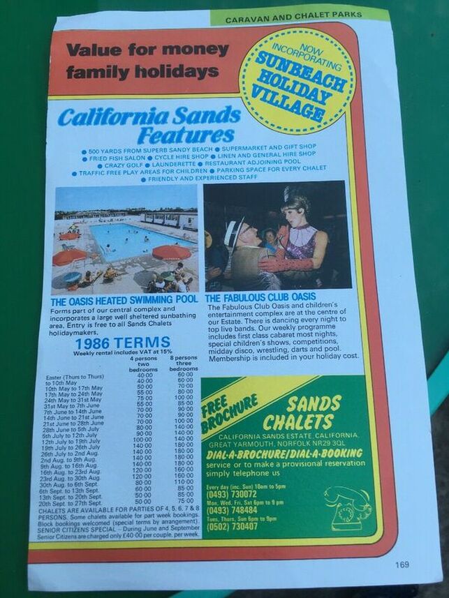
California Sands Estate
Picture
The California Tavern
Around 1800 a migration took place along the coast of East Norfolk by people who had  previously worked on the land. These people organised  themselves into beach companies’  in  order to benefit from the rapidly expanding Yarmouth Herring Industry by earning  a living salvaging the many vessels that had come to grief on the maize of sandbanks that lurked just below the surface of the sea.  The men became known as 'beachmen' .
Around 1840 a group of beachmen from Winterton moved south and established the California settlement which was so named because of  Gold coins being found in the cliffs at the time of the California Gold Rush. California had the advantage of a clear view of the sandbanks from Happisburgh to Corton including the sheltered anchorage in Yarmouth  where up to  1000 sailing ships would await a favourable wind.
A lookout tower  was erected on the cliffs and  vessels called ‘Gigs’ and ‘Yawls’ were purpose built for salvage work.  In 1854 the beachmen also  had a lifeboat built by the famous Yarmouth boat builders James Beeching, to enable  them to carry out more hazardous work. Permission was granted from the Prince Consort to name the  lifeboat ‘Prince Albert’  and under the leadership of Coxswain Solomon Brown, many notable rescues were carried out .(Solomon Brown is far right, back row in the right hand picture above)
However from around 1880 erosion started to affect the work of beach companies with the loss of  both beach and cliffs, this eventually resulted in the loss of the lookout, and subsequently the original California Tavern, to the sea. By 1890 the California beach companies ceased to exist and the beachmen migrated to Caister and joined the beach companies there.
The future for California now lay in the booming tourist industry where people originally came to Norfolk via the railways to enjoy the golden beachs and stay in the fast developing Holiday Camps.


John Cannell.
Powered by Create your own unique website with customizable templates.