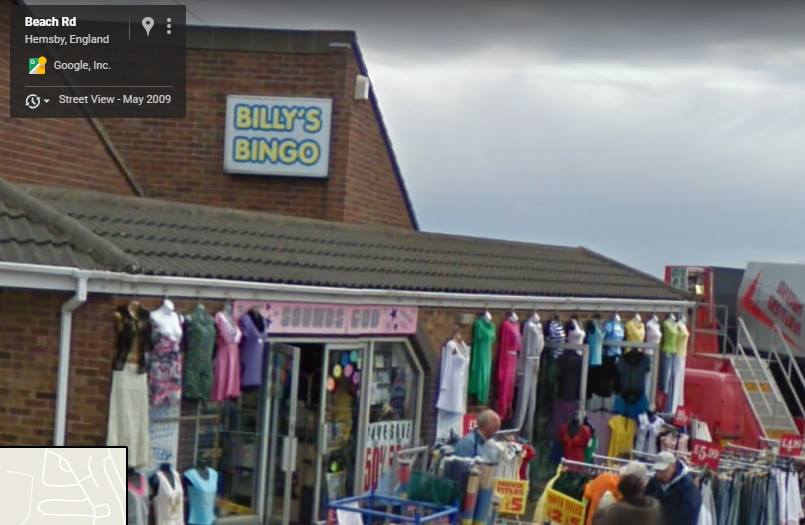
Sprowston History
  • Home
  • Sprowston Road Index
    • Roads A >
      • Aiken Close
      • Alford Grove
      • Allens Avenue
      • Amos Bacon Close
      • Aslake Close
      • Avian Way
      • Avocet Rise
    • Roads B >
      • Barkers Lane
      • Blackwell Avenue
      • Blenhiem Road
      • Blithemeadow Drive
      • Blue Boar Lane
      • Breck Road
    • Roads C >
      • Cannerby Lane
      • Cecil Gowing Court
      • Cere Road
      • Chartwell Road
      • Chenery Drive
      • Church Green
      • Colindeep Lane
      • Constitution Hill
      • Corbet Avenue
      • Cozens Hardy Road
      • Creance Road
      • Cromwell Road
    • Roads D >
      • Dixons Fold
      • Dovedales
    • Roads E >
      • Edwards Road
    • Roads F >
      • Falcoln Road West
    • Roads G >
      • Glenburn Avenue
      • Goshawk Mews
    • Roads H >
      • Hammond Way
      • Harrisons Drive
      • Holly Bank
      • Hornbeam Close
    • Roads L >
      • Lambert Road
      • Linacre Avenue
      • Lone Barn Road
      • Lusher's Loke
    • Roads M >
      • Mallard Way
      • Merlin Avenue
      • Millwrights Way
      • Mousehold Lane
    • Roads N >
      • Neville Road
      • North Walsham Road
    • Roads P >
      • Parkland Road
      • Pinetrees Road
    • Roads R >
      • Recreation Ground Road
      • Rosemary Road
      • Roundtree Way
    • Roads S >
      • Salhouse Road
      • School Lane
      • Shipfield
      • Sparhawk Avenue
      • Sprowston Road
      • St Georges Loke
      • Stonehouse Road
    • Roads T >
      • Tills Road
      • Tills Close
      • Tusting Close
    • Roads V >
      • Varvel Avenue
    • Roads W >
      • White Woman Lane
      • Wilks Farm Drive
      • Woodside Road
      • Wroxham Road
  • Timeline
  • Other Areas
    • Other Roads A >
      • Airedale Close
      • All Saints Green
      • Amsterdam Way, Hellesdon
      • Angel Road
      • Anglia Square
      • Aylsham Road, Banningham
      • Aylsham Road, Norwich
    • Other Roads B >
      • Bacton Road, North Walsham
      • Back Of The Inns, Norwich
      • Barnard Road, Bowthorpe
      • Barrack Street, Norwich
      • Baxter Court, Norwich
      • Beach Road, Hemsby
      • Bedford Street, Norwich
      • Bell Road, Norwich
      • Bessemer Road, Norwich
      • Ber Street
      • Bethel Street
      • Borrowdale Drive
      • Botolph Street, Norwich
      • Boundary Road, Hellesdon
      • Bowthorpe Road
      • Branford Road
      • Bridge Road, Potter Heigham
      • Britannia Rd
      • Bull Close
      • Burma Road, Old Catton
      • ​Bussey Road, Fiddlewood
      • Buxton Road, Spixworth
    • Other Roads C >
      • Cabbell Road, Cromer
      • California Road, California
      • Calvert Street, Norwich
      • Carrow Road
      • Castle Meadow, Norwich
      • Castle Gardens, Norwich
      • Castle Street, Norwich
      • Castle Street, Wroxham
      • Catton Chase
      • Catton Grove Road
      • Cambridge Street, Norwich
      • Chapel Road, Roughton
      • Chapelfield Road
      • Charing Cross
      • Church Street, Cromer
      • Church Plain, Great Yarmouth
      • Church Road, Hoveton
      • Church Road, Upton
      • Churchill Road, Great Yarmouth
      • Clancy Road
      • Coast Road, Bacton
      • Concorde Road
      • Connaught Road
      • Cowgate
      • Cozens Road
      • Cremorne Lane
      • Cromer Road, Hellesdon
      • Cromer Road, Mundesley
      • Cromer Road, West Runton
    • Other Roads D >
      • Dales Loke, Thorpe St Andrew
      • Daniels Road, Norwich
      • Davey Place
      • Denmark Road
      • Dereham Road, Norwich
      • Diamond Road, Norwich
      • Dog Lane, Horsford
      • Drayton High Road
      • Drayton High Street, Drayton
      • Drayton Road, Mile Cross
      • Duke Street, Norwich
      • Dussindale Drive
    • Other Roads E >
      • Eade Road
      • Earlham Road, Norwich
      • Edwards Street, Norwich
      • Esdelle Street, Norwich
      • Eversley Road
    • Other Roads F >
      • Farmers Avenue
      • Fifers Lane
      • Furze Road, Thorpe St Andrew
      • Fye Bridge Street
    • Other Roads G >
      • Garden Street, Cromer
      • Gentlemen's Walk, Norwich
      • Golding Place
      • Grammar School Road, North Walsham
      • Guardian Road
      • Guildhall Hill
      • Gurney Road
    • Other Roads H >
      • Halls Corner, Hevingham
      • Harvey Lane
      • Havers Road
      • Haymarket, Norwich
      • Heartsease Lane
      • Heigham Street
      • Hemming Way, Norwich
      • Henby Way, Thorpe St Andrew
      • High Street, Coltishall
      • Hillcrest Road
      • High Street, Cromer
      • High Street, Mundesley
      • Holt Road, Cromer
      • High Street, Overstrand
      • Hooker Road, Heartsease
      • Horning Road, Hoveton
      • Holt Road, Hellesdon
      • Holt Road, Horsford
      • Honeycombe Road, Salhouse
      • Hurricane Way
    • Other Roads I >
      • Ipswich Road
    • Other Roads J
    • Other Roads K >
      • Ketts Hill
      • King Street, Norwich
    • Other Roads L >
      • Laundry Lane, Thorpe St Andrew
      • Lodge Lane, Old Catton
      • London Street, Norwich
      • Lower Goat Lane
      • Lower Street, Salhouse
    • Other Roads M >
      • Magdalen Road
      • Magdalen Street
      • Manor Road, Newton St Faith
      • Market Gate Shopping Centre
      • Market Place, Aylsham
      • Market Place, Great Yarmouth
      • Market Street, North Walsham
      • Marine Parade, Great Yarmouth
      • Marryat Road
      • Middlebrook Way, Cromer
      • Mill Road, Cromer
      • Mill Road, Salhouse
      • Millenium Plain, Norwich
      • Millgate, Trowse
      • Mile Cross Lane
      • Mile Cross Road
      • Millers Lane
    • Other Roads N >
      • Nelson Street, Norwich
      • New Road, North Walsham
      • North Walsham Road, Beeston St Andrew
      • North Walsham Road, Trunch
      • Norwich Research Park
      • Norwich Road, Aylsham
      • Norwich Road, Horsham St Faith
      • Norwich Road, Hoveton
      • Norwich Road, Marsham
      • Newport Road, Newport
      • Norwich Road, North Walsham
      • Northumberland Street, Norwich
      • Norwich Road, Wroxham
    • Other Roads O >
      • Oak Street, Norwich
      • Old Road, Acle
      • Old Library Mews
      • Orford Hill, Norwich
      • Orford Place, Norwich
    • Other Roads P >
      • Park Avenue, Scottow
      • Philadelphia Lane
      • Plumstead Road, Norwich
      • Plumstead Road, Thorpe End
      • Plumstead Road East
      • Pottergate
      • Pound Lane, Thorpe St Andrew
      • Prince Of Wales Road, Norwich
      • Priory Plain, Great Yarmouth
    • Other Roads Q >
      • Quebec Road, Norwich
      • Queens Road
    • Other Roads R >
      • Rampant Horse Street Norwich
      • Regent Road, Great Yarmouth
      • Reepham Road, Hellesdon
      • Riverside Centre, Hoveton
      • Riverside Road, Norwich
      • Rosary Road
      • Rose Lane, Norwich
      • Roundtree Close
      • Rouen Road
      • Runton Road, Cromer
    • Other Roads S >
      • Salhouse Road, Rackheath
      • Sae View Road, Hemsby
      • Silver Street, Norwich
      • South Hill Road, Thorpe St Andrew
      • South Market Road, Great Yarmouth
      • Southwell Road, Horsham St Faith
      • Spar Road, Norwich
      • Spixworth Road, Old Catton
      • St Augustines Street
      • St Benedict's Street, Norwich
      • St Faiths Road, Old Catton
      • St Giles Street
      • St Leonards Road
      • St Nicholas Road, Great Yarmouth
      • St Stephens Road
      • St Stephens Street
      • St Thomas Road, Hemsby
      • Stalham Road, Hoveton
      • Station Road, Hoveton
      • Station Road, West Runton
      • Surrey Street, Norwich
      • Swan Lane
    • Other Roads T >
      • The Green, Martham
      • The Paddocks, Old Catton
      • The Street, Brundall
      • The Street, Hemsby
      • Thorpe Avenue
      • Thorpe Road, Norwich
      • Thunder Lane, Thorpe St Andrew
      • Timberhill
      • Tombland
    • Other Roads U >
      • Unthank Road
    • Other Roads V >
      • Vulcan Road North / South
    • Other Roads W >
      • Waterloo Road
      • Watling Road, Heartsease
      • West End Street, Norwich
      • West Street, Cromer
      • Westlegate, Norwich
      • Westwick Street, Norwich
      • Weston Hall Road
      • Whiffler Road
      • White Lion Street, Norwich
      • Woodcock Road
      • Woodham Leas
      • Wroxham Road, Rackheath
    • Other Roads X
    • Other Roads Y >
      • Yarmouth Road, Caister On Sea
      • Yarmouth Road, North Walsham
      • Yarrmouth Road, Thorpe St Andrew
    • Other Roads Z
  • Links & Local Books
  • Credits
  • Contact Me
  • Salhouse Road
  • Hemsby - List of old shops and arcades
  • Egyptian Road
  • Lollard Road
  • Station Road, Coltishall
  • Whimpwell Green, Happisburgh
  • North Walsham Road, Scottow

Fiveways

Picture

Hemsby

Maria's
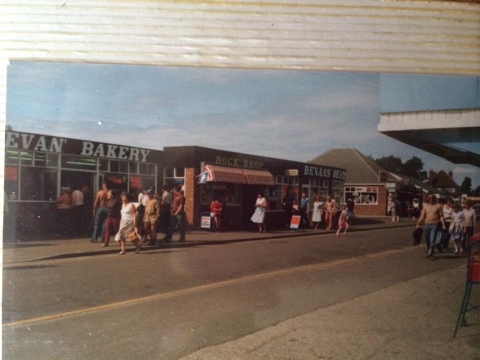
Used to be Robinson's and later Bevans.


Bohemian Ink
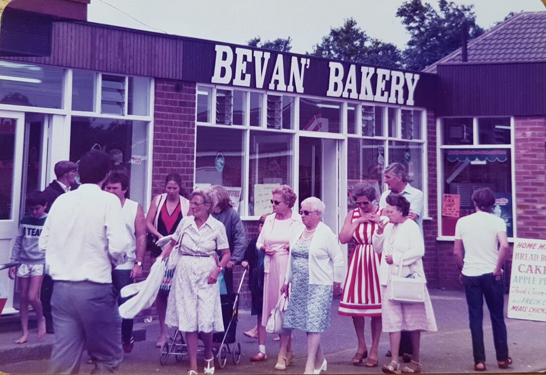
Used to be Bevan's Bakery. Ran by Lorna Bevans mum.


Picture
Picture
Caesars
Used to be a supermarket
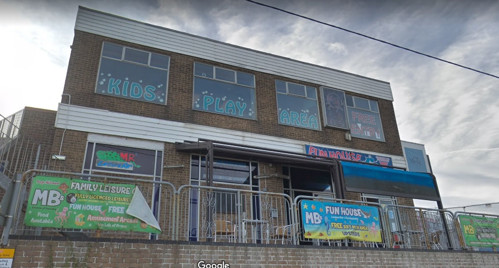
MB's Funhouse
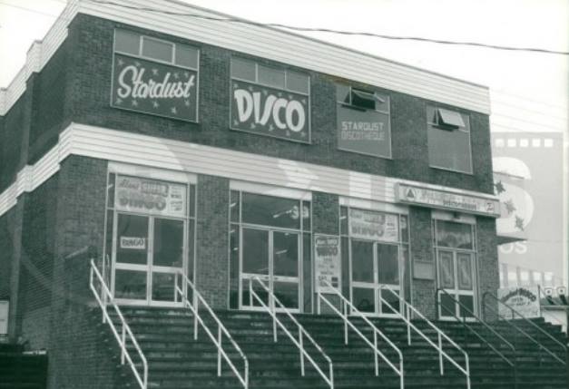
Used to Stardust Disco and later MB's Nightclub.
Picture
Picture
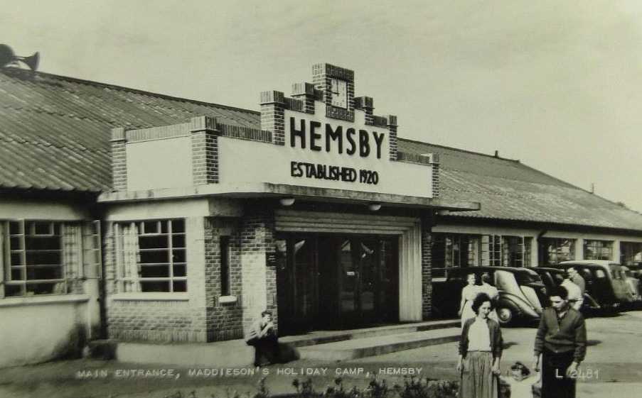
Hemsby Beach Holiday Park
This started out as Maddison's Holiday Camp in 1920. Now run by Richardsons and this building has been flattened. It became Seacroft in the 1960's and was owned by the Bishop family.
Picture
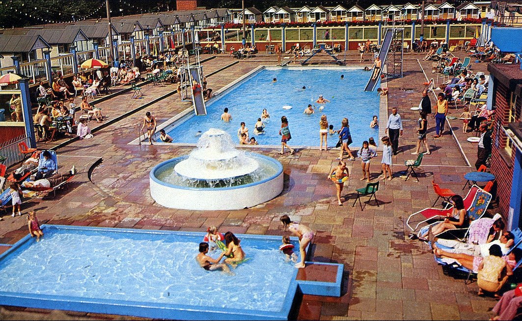
This area is now the park near the clubhouse. The bowling green is still there but not used for bowls anymore I don't think. Seacroft was owned by the Bishop family in the 1960s ​
Picture

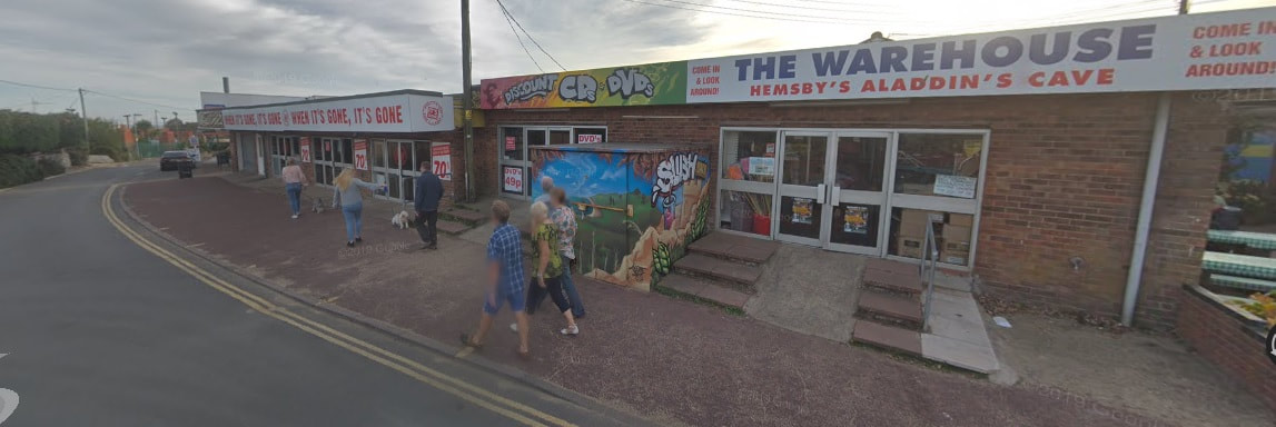
Used to be Two Way Arcade
Picture
This used to be Saturn's Palace and the chip shop next door. The chip shop caught fire on July 31st 
2015 due to the chip pan catching fire and set fire to the arcade next door as well. Now demolished.
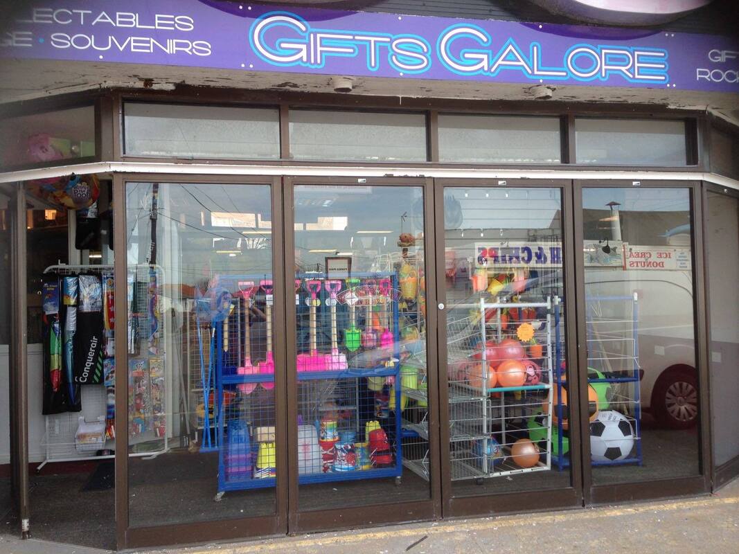
Picture
Gifts Galore
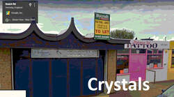
Used to be Crystals Arcade
Picture

Picture

Picture
Picture
Palace Casino
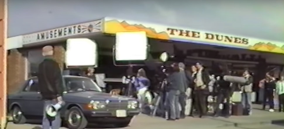
Used to be The Dunes arcade. 

​In September 1989 the Hemsby beach resort near Great Yarmouth in the UK became a movie set for a day or two. The late Christopher Lee, at the time still best known for his Hammer Horror movies, came to the seaside village with Anglia TV to film action scenes for a spy thriller, 'The Care of Time'. Hemsby was chosen for a sequence set in Florida! The first showing of these re-discovered clips, shot on the fly with an early camcorder. Admittedly shaky in places - no image stabilising back then and post-stabilising would crop on what is already low-resolution footage. So shown here in it's raw form albeit a few edits. The conversion and rendered file is not the best (the original VHS-C tape is far better) but hopefully this will be of interest to a few. Perhaps a curiosity at least to Chris Lee fans and more especially local people whose beach has suffered badly from erosion over the years. If anyone can put names to any crew and particularly Chris Lee's stunt double or any trivia relating to that day, please share. Perhaps there's an old recording around, ie. the finished action sequence which made the final cut! Music: Take Five - Dave Brubeck Quartet, Yachts - AMCA, Guaglione - Giuseppe Fanciulli, Kalimba - "Mr Scruff".


Picture
61 Holt Road, Hellesdon - Hellesdon Vets
Used to be a Chinese cafe and Taverham Conservatorys
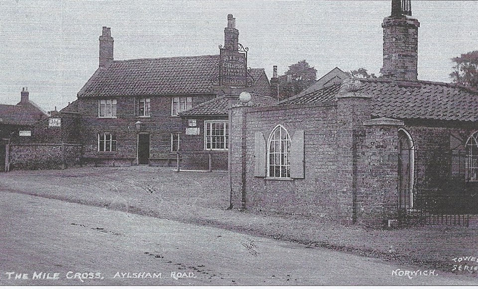
Mile Cross Lane

Picture
B&M​
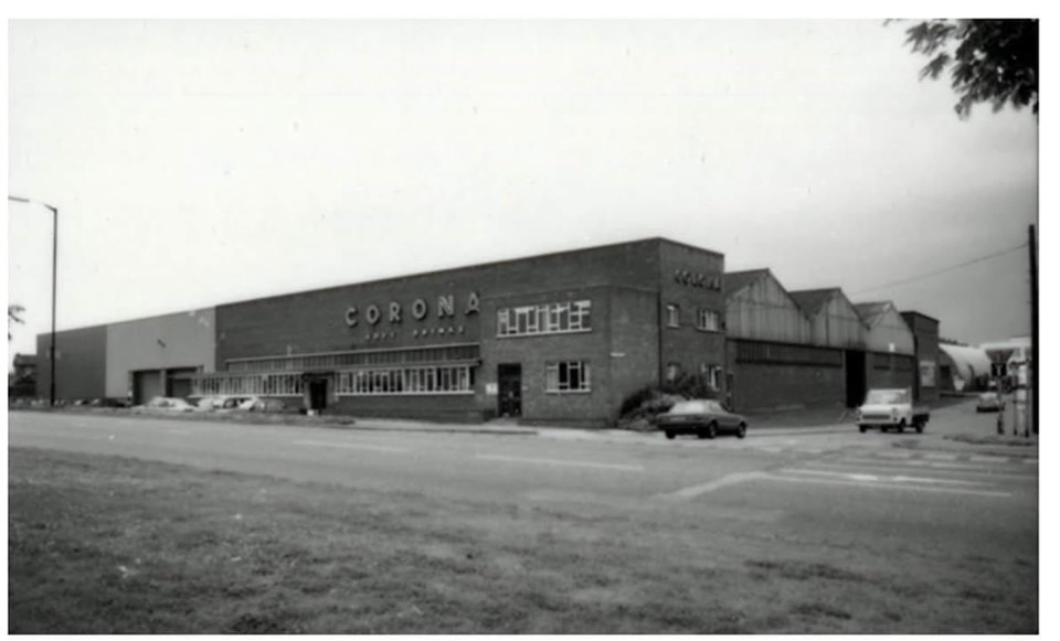
Used to be Corona bottling factory, Texas DIY then from 1996 - 1998 it was rebranded as Homebase then Comet and then B&M.

KFC

Was Bush Builders then Willmott And Dixon.
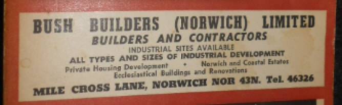
Picture
1970 - 1971 advert

Norwich Road, Wroxham

10 Norwich Road - Norfolk Broads Information Center
Used to be Stringers Family Butcher. Credit
12 Norwich Road - Wroxham Laundrette
This used to be a grocery store run by rwo Mrs Woods. Credit
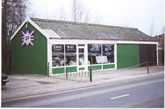
24 Norwich Road - Riverside Arts And Glass
The building next to it used to be a garage owned at that time by Brian Jermyn and once called Batsons Garage. It was built in the early 1920's, Now a car showroom for David Wall.
Picture
166 Norwich Road, Wroxham
Used to be Carman Stores.
173 Norwich Road
Used to be Petals florist and before that it was a greengrocers, owned at one time by Maudie Baine.
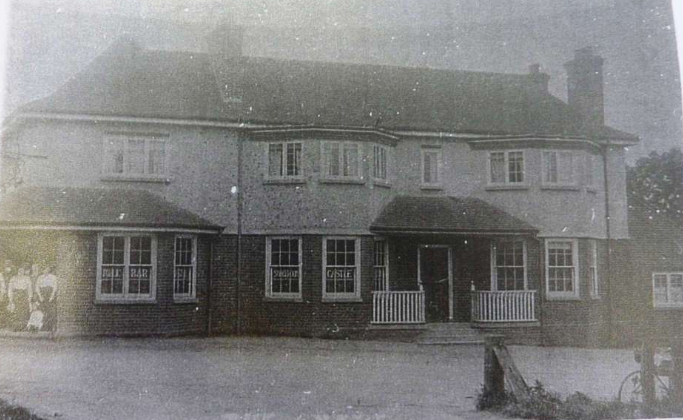
208 Norwich Road
Used to be the Castle Inn pub.
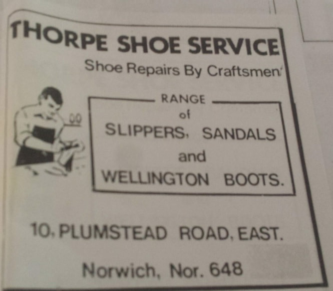
Picture

Plumstead Road East

10 Plumstead Road East - Thorpe Shoe Service
Picture

Spixworth Road

Picture
1973

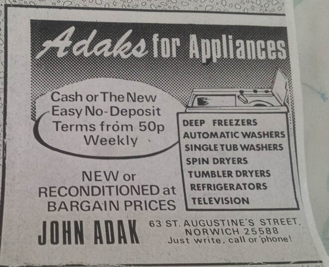
​St Augustine's Street

63 St. Augustine's Street - Adaks For Appliances
Picture

St Faiths Road

282 St Faiths Road - Mace Shop
Picture
Picture

Thorpe Avenue, Thorpe St Andrew

Picture
2 Thorpe Avenue - Nansa Charity Shop
Used to be a Butchers then a Plug And Socket electrical shop.
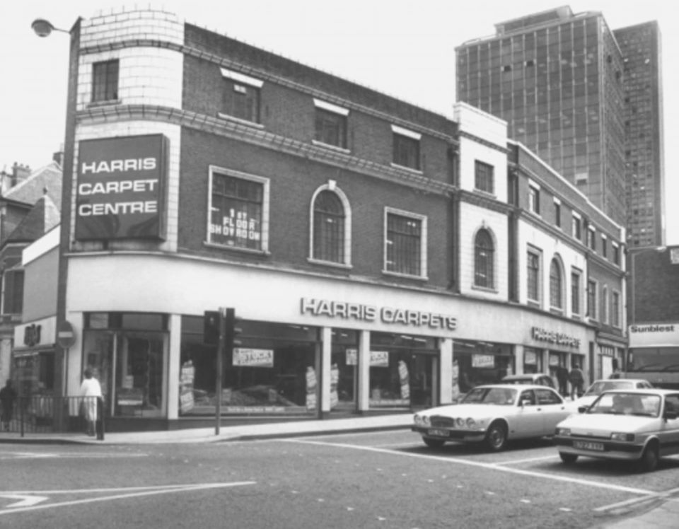
Westlegate

Tesco Westlegate Express - 2-8 Westlegate
oes anyone know the history of this building? Now Tesco, used to be JJB, prior to that it used to be Harris Carpet Center, but what was before that.....????Hardys - furniture shop
Picture
Picture

White House Court

Mile Cross Inn 1910. Now White House Court
Picture
Powered by Create your own unique website with customizable templates.