
Salhouse Road
Trivium Packaging UK Tld - Salhouse Road
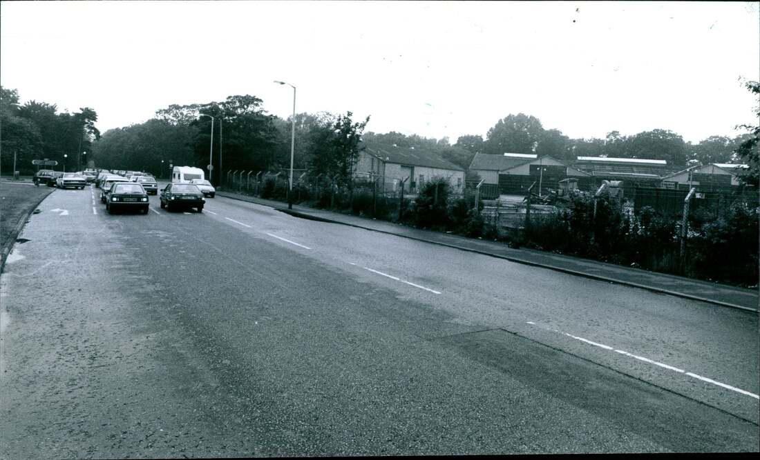
Used to be Clover Tin Company
Used to be Clover Tin Company
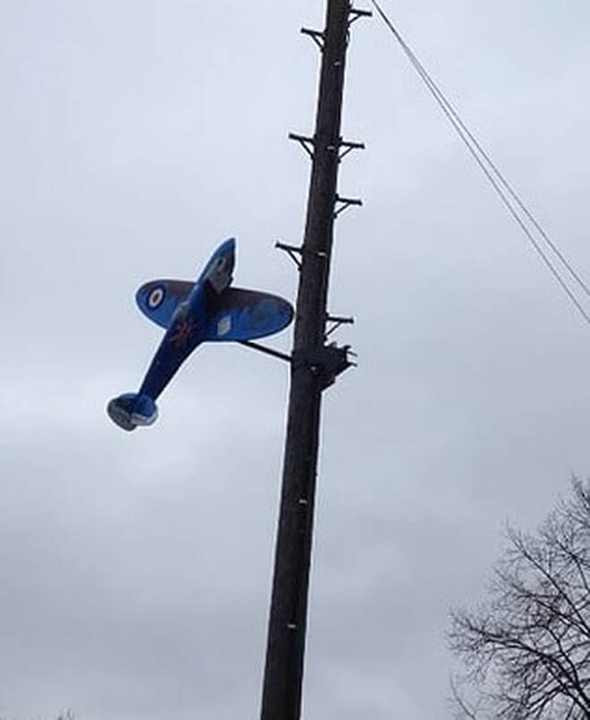
On the corner of Salhouse Road and Mousehold Lane is a model aircraft which you can see below. It was put there to commemorate the 100 years of the RAF.
Sprowston Retail Park
There used to be a big Boulton & Paul building near the corner of Salhouse Road and Moushold Lane. They made aircraft. I need more info please help! There was also aerodrome cottages where Dunelm Mill now stands.
Unit 1 -2 - Dunelm Mill used to be Millers Bros Electrical. Unit 2 started out as Pets At Home and moved to Unit 4
Unit 3 - Carptet Right
Unit 3A - Dreams
Unit 4 - Pets At Home
Unit 5 - DFS
Unit 6 - Harveys
Unit 7 - Sofology
Unit 8 - Wren Living
Unit 9 - Furniture Village
Unit 10 - S.C.S. used to be Texstyle World
Unit 11 - JJB Sports
Unit 11a - Oak Furniture
Unit 11b - KFC
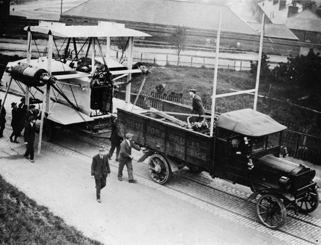
Below is parts for an aircraft being transported from Thorpe Train Station on the mini railway through Mousehold and into the yards of Boulton And Paul on Salhouse Road.
12 Salhouse Road
While walking down the road I noticed the houses start at no 12! Anyone know what happened to the rest?! Maybe Nos 2-10 were also there once but knocked down to make way for Heartsease High when it was built? The school opened in 1965 so they must have been knocked down a few years before that.
While walking down the road I noticed the houses start at no 12! Anyone know what happened to the rest?! Maybe Nos 2-10 were also there once but knocked down to make way for Heartsease High when it was built? The school opened in 1965 so they must have been knocked down a few years before that.
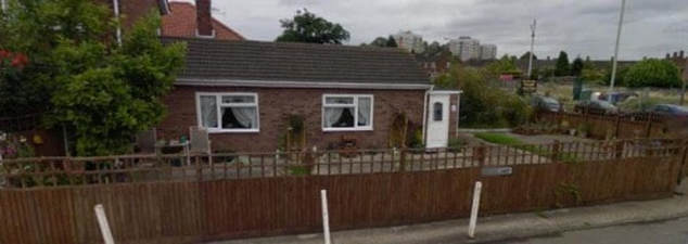
99 Salhouse Road
The bungalow in the picture below used to be a Cafe called Anne's Café and was run by Anne George. I've also been told there used to a parrot here that swore lots! There was also a poodle dog roaming the café! This has now closed and has been transformed back into the bungalow you can see below. Anyone know when it closed as a café?
The bungalow in the picture below used to be a Cafe called Anne's Café and was run by Anne George. I've also been told there used to a parrot here that swore lots! There was also a poodle dog roaming the café! This has now closed and has been transformed back into the bungalow you can see below. Anyone know when it closed as a café?
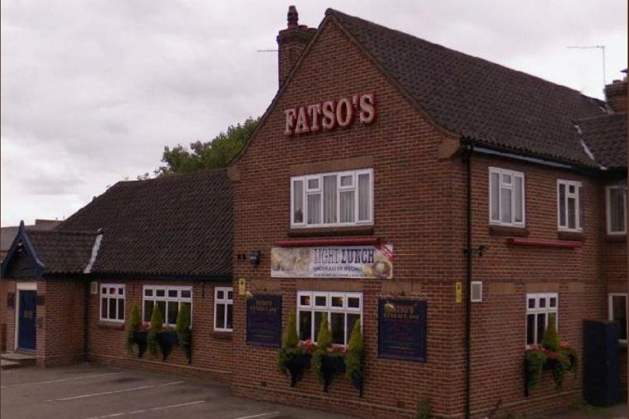
107 Salhouse Road - Fatso's
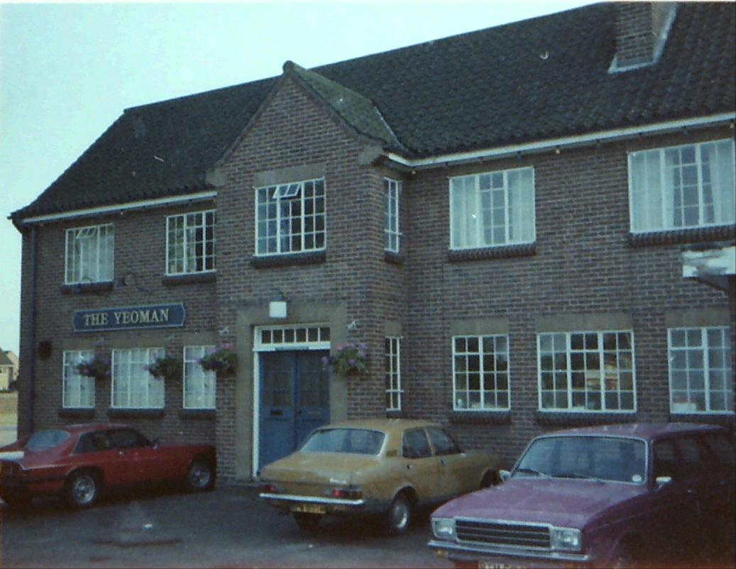
This used to be called The Yeoman and opened in March 1957 around the same time as the Heartsease Estate estate was being built. The first landlord was Percy Shepheard and shortly after Harold Burnham and his wife Doris took it over and ran it till 1983 when he retired. The pub was possibly named in honour of the Norfolk Yeomanry, formed in 1785.
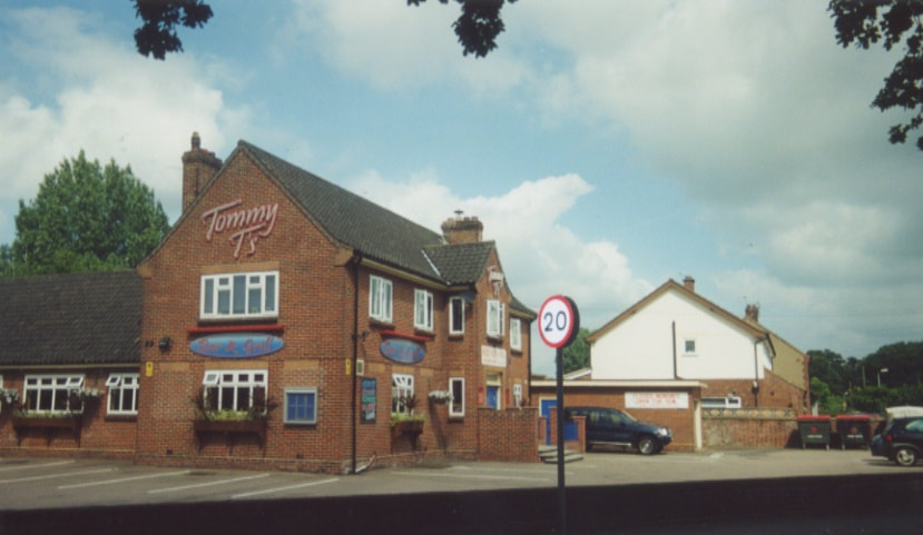
In 2001 the then landlord of the Blue Boar on Wroxham Road David Turnbull took over and renamed it Tommy T's which was named after David's son This was an American style burger and steak house. The restaurant was famous for its "Elvis Burger" which was massive. I know as I ate a couple of them and felt very full afterwards!
In 2007 it changed to Fatso's and is now run by Anglia Restaurants. If you look at the entrance on Falcoln Road you can actually still see an old Tommy T's sign!
This used to be called The Yeoman and opened in March 1957 around the same time as the Heartsease Estate estate was being built. The first landlord was Percy Shepheard and shortly after Harold Burnham and his wife Doris took it over and ran it till 1983 when he retired. The pub was possibly named in honour of the Norfolk Yeomanry, formed in 1785.
In 2001 the then landlord of the Blue Boar on Wroxham Road David Turnbull took over and renamed it Tommy T's which was named after David's son This was an American style burger and steak house. The restaurant was famous for its "Elvis Burger" which was massive. I know as I ate a couple of them and felt very full afterwards!
In 2007 it changed to Fatso's and is now run by Anglia Restaurants. If you look at the entrance on Falcoln Road you can actually still see an old Tommy T's sign!
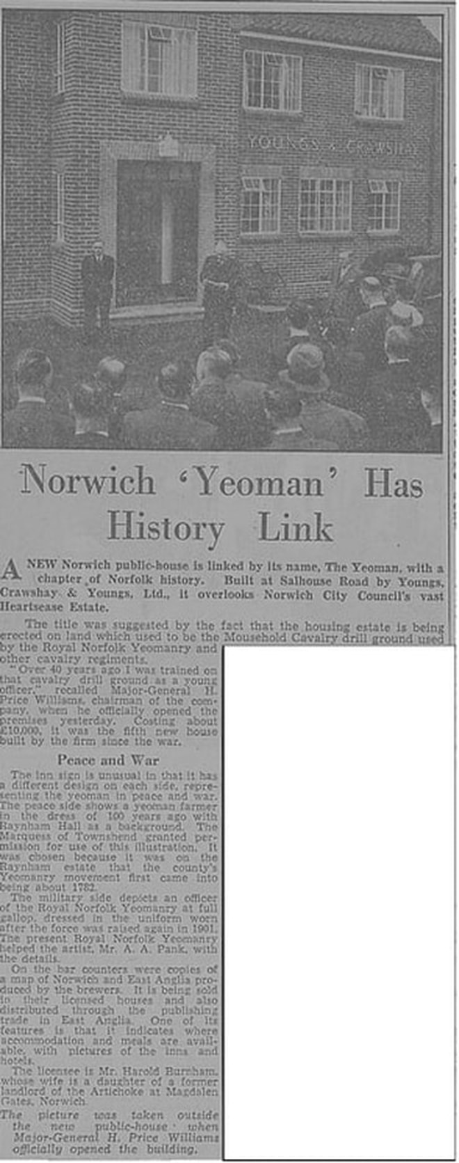
1957 Copyright Archant
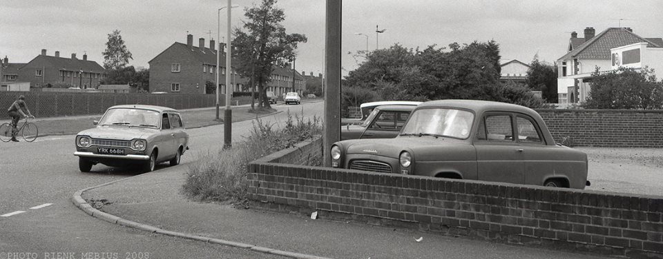
Photo - kind permission from Rienk Mebius / http://www.rienkmebius.nl/
http://www.norridge.me.uk
109 Salhouse Road
This used to be a butchers shop called Browns and later Palmers Butchers. It was converted to a house in 2003.
This used to be a butchers shop called Browns and later Palmers Butchers. It was converted to a house in 2003.
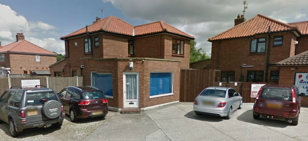
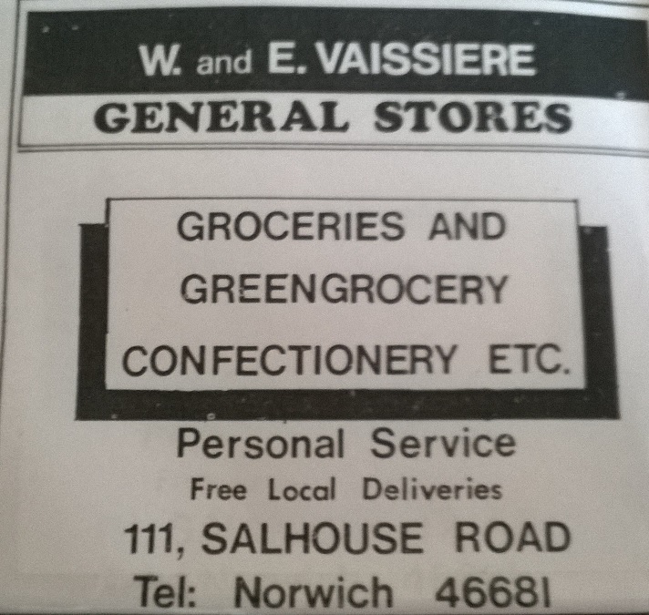
111 Salhouse Road - The Card Shop
The card shop was originally a grocer shop under the name of Goldsmith and also W. & E. Vaissiere. I also remember it as a second hand shop in the late 90's I think.
The card shop was originally a grocer shop under the name of Goldsmith and also W. & E. Vaissiere. I also remember it as a second hand shop in the late 90's I think.
11B Sprowston Retail Park - Barnards Fencing
Used to be JJB Sports and now KFC. The factory was a 15 acre site was in use between 1826 and 1990. They invented wire netting. They used to produce chain-link fencing by machine. They also made lighthouses off the coast of Brazil and made the gates at Sandringham. They also made the Chessington Zoo in Surrey, later to become Chessington World of Adventures train. More info here. They closed in 1991 and was replaced by the Sprowston Retail Park. Barnards Fencing or sometimes known as Barnard's Iron Works was bombed on 9th July 1940 during the second world war, killing four men as reported in this story here. Later known as Tinsely Wire Industries
CJ Ball
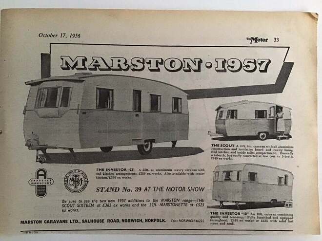
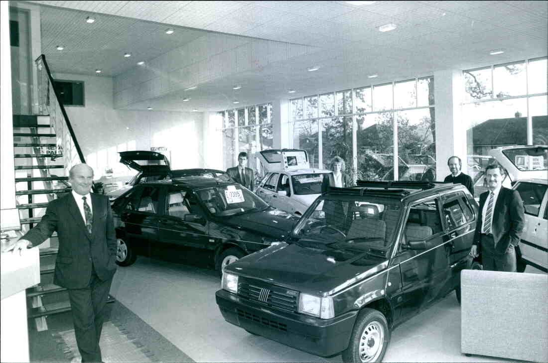
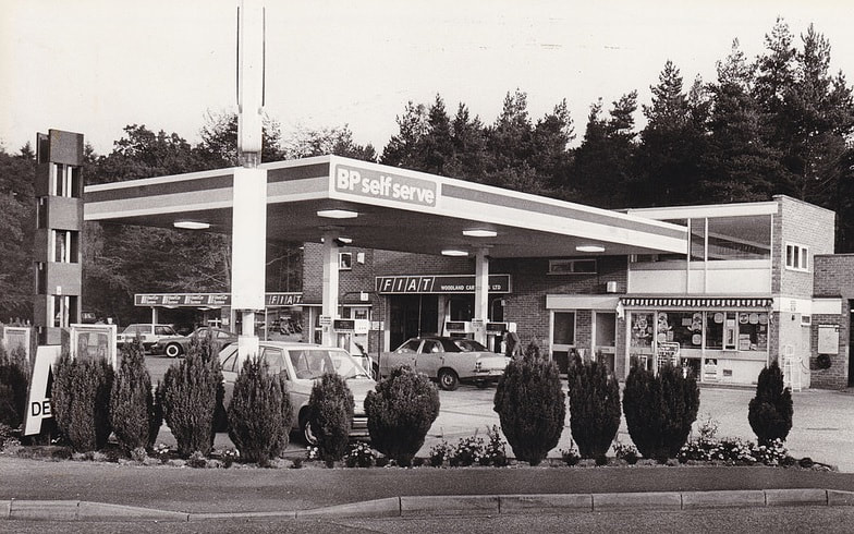
Marston Caravans Ltd used to be here in 1956. Later th petrol station opened around 1969. In the 60's it was managed by Alfie Shailer and it was originally called Woodland Car Sales.
In 1973 it was still Woodland Car Sales and behind was a camping shop which also sold Camapri inflatables.
It got redeveloped in the late 80's so that it was just a BP Petrol Station and added a car wash round the back.
In 1984 it was Hazeldean car sales
Duffield Marine Ltd was where the main CJ Ball showroom is now.
Ray Gimbert on Facebook tells "I used to work on the pumps at Woodland Car Sales and my Dad Bob Gimbert ran it. "As far as I can recall it's always been a BP filling station. Dad is long gone now, but when he bought into the company, he had a showroom added to the workshops (where the main CJ Ball shop is now) which after several successful years of trading was then pulled down and rebuilt into it's current configuration. After dad retired, it was then split into two business's, where dad's partner retained the petrol sales, but sold on the workshops and new showrooms.
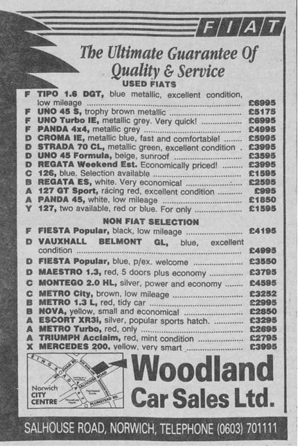
The garage promoted both Simca and Fiat franchises and for a short time Rootes, seeing in the Hillman Imp. Reverting back to Fiat and then to Alfa after Simca was swallowed up by Rootes. In the early 90s The Lind Group acquired the business and franchises, moving them to Heigham St. T The forecourt continues for several more years run by Paul Caston. CJ Ball opened in 2012. CJ Ball was established back in the 50's in Hales.
Marston Caravans Ltd used to be here in 1956. Later th petrol station opened around 1969. In the 60's it was managed by Alfie Shailer and it was originally called Woodland Car Sales.
In 1973 it was still Woodland Car Sales and behind was a camping shop which also sold Camapri inflatables.
It got redeveloped in the late 80's so that it was just a BP Petrol Station and added a car wash round the back.
In 1984 it was Hazeldean car sales
Duffield Marine Ltd was where the main CJ Ball showroom is now.
Ray Gimbert on Facebook tells "I used to work on the pumps at Woodland Car Sales and my Dad Bob Gimbert ran it. "As far as I can recall it's always been a BP filling station. Dad is long gone now, but when he bought into the company, he had a showroom added to the workshops (where the main CJ Ball shop is now) which after several successful years of trading was then pulled down and rebuilt into it's current configuration. After dad retired, it was then split into two business's, where dad's partner retained the petrol sales, but sold on the workshops and new showrooms.
The garage promoted both Simca and Fiat franchises and for a short time Rootes, seeing in the Hillman Imp. Reverting back to Fiat and then to Alfa after Simca was swallowed up by Rootes. In the early 90s The Lind Group acquired the business and franchises, moving them to Heigham St. T The forecourt continues for several more years run by Paul Caston. CJ Ball opened in 2012. CJ Ball was established back in the 50's in Hales.
Credit: Archant & https://www.localrecall.co.uk/
Credit: Archant & https://thestoryof.uk/
 1985 Credit: Not known
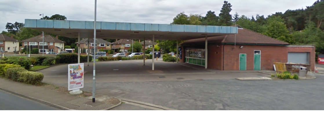
2011
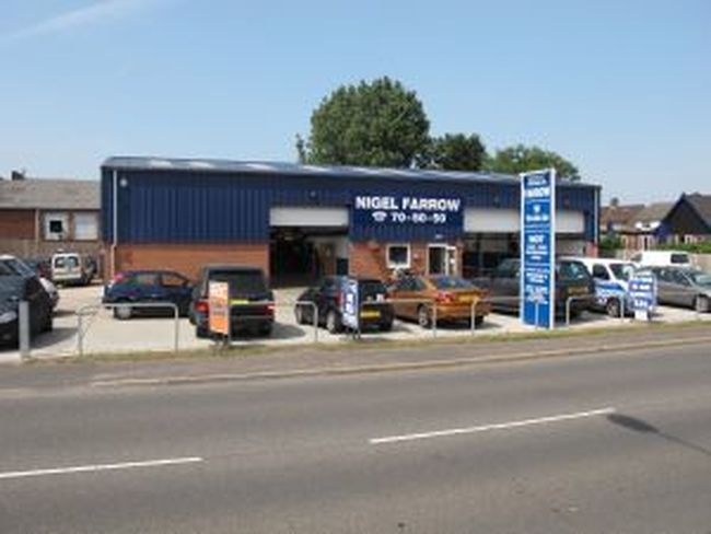
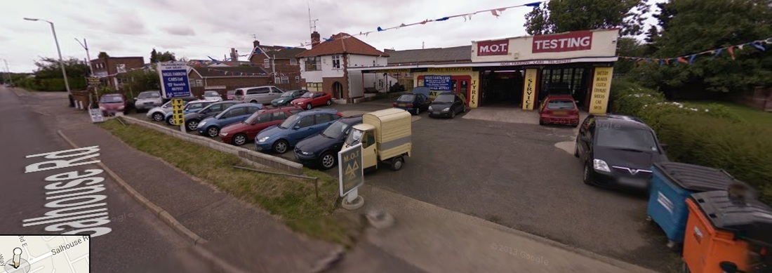
101-105 Salhouse Road - Nigel Farrow Cars
In 1960 this was Salhouse Road Service Station and it was an Esso garage and owned by Mr A Wright.. In 1979 the Esso petrol pumps were removed and it became a car sales showroom called Salhouse Road Car Sales.. Clive Atthowe Car Tuning Sevices was here once. Established in 1989 on another site on 32-36 Harvey Lane and the company moved to new premised in 2012 on the old site that used to be the Esso petrol station and later Goldstar Taxis. In 2009 Nigel Farrow Cars demolished the old site with the old house that housed Goldstar taxis.
Established in 1989 Nigel Farrow Cars Ltd. moved into it’s new, purpose built premises at 101 Salhouse Road in 2012. Our MOT Testing Station and service repair workshop comprises of three MOT bays for testing cars, light vans, heavy vans, motorhomes and a five bay workshop where we can service and repair all makes and models of vehicles. Since it was finished in 2012 to our specifications, we are welcoming customers who have been with us for many years (some from the very beginning) and look forward to meeting new customers on a daily basis.
from website - https://nigelfarrowcars.co.uk/

Copyright Archant
2008
Open Academy (formerly Heartsease High School)
This corner opposite Homebase used to be be Roundtree Corner. It opened in 1965 as Heartsease Secondary School. Built by Carter builders. The first headmaster was Mr Browning. This was the Heartsease School which became comprehensive and carried a total of 1200 boys and girls on roll when he retired in 1982. Here he is below. More info on John here http://www.sohamgrammar.org.uk/browningj.htm
This corner opposite Homebase used to be be Roundtree Corner. It opened in 1965 as Heartsease Secondary School. Built by Carter builders. The first headmaster was Mr Browning. This was the Heartsease School which became comprehensive and carried a total of 1200 boys and girls on roll when he retired in 1982. Here he is below. More info on John here http://www.sohamgrammar.org.uk/browningj.htm


 2008 - Where Open Academy now stands
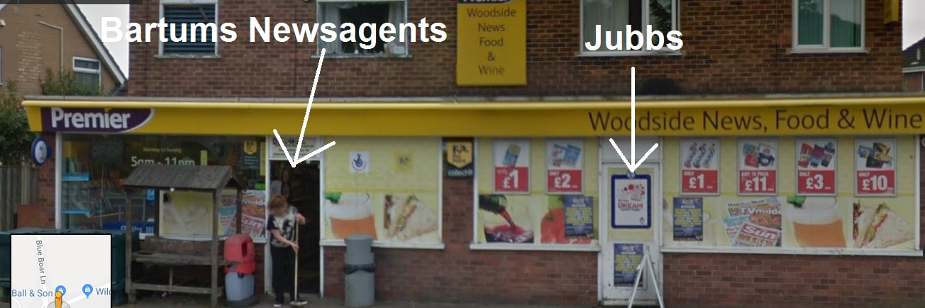
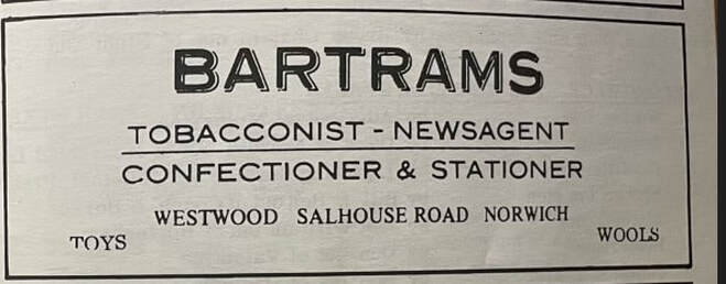
170-172 Salhouse Road - Woodside News, Food And Wine
The shop was completely redone in September 2022 and no trace of the old shop front now exsist but if you look at this old picture before it was done this shop had 2 doors. This was once actually 2 shops once called Bartams and Jubb's.
Bartum's Newsagents was on the left hand side at no 170. It was run by Frank and Elsie Bartram. It later became a Mace shop. It was once Lavells Ltd in 1987
Jubb's was on the right hand side of Woodside News as you look at it today at No 172. Alan and Jean Jubb owned the shop for over 30 years and it was a Mace grocery shop. They sold the shop in 1976. Jubbs was sold to Doug and Sarah and then knocked into one as it is today. Thanks to John Jubb (Alan and Jean's son) who emailed me.
There was briefly a kebab van on the car park around 2015 but didn't last very long.
December 2022 update:
The whole shop and front has been changed and now is all one unit. It looks really good.
174 Salhouse Road - Christine Hair Stylist
Opened in 1965.
Opened in 1965.
177 Salhouse Road - Unit 5 Caston Industrial Estate - Scandia
Used to be B.L Griffiths stone enmaellers in 1983
Used to be B.L Griffiths stone enmaellers in 1983
186-200 Salhouse Road - Wilco / Fastfit
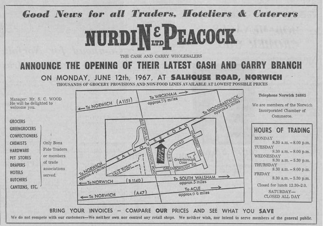
This used to be Breck Farm. In 1958/1959 it became Clarke's Egg Packing Station and later it became New Lay Eggs.
In 1967 it was Nurdin and Peacock Cash And Carry. In 1974 it was Norwich Grocers Ltd. It later became K.J Shortis which then turned into a Wilco stores owned by The Shortis Group. and in October 2013 they celebrated 50 years in the trade. The company started in a small shop on Barn Road.
Taken from their website here is a little history lesson about the company.
"The Wilco success story started in 1963 when Kevin Shortis as a 23 year old opened his first Motorist Discount Store in Norwich, bringing cut price, branded products to local car owners. It was an immediate hit. More stores were opened until in 1971 the company was taken over. However, this was not successful, due to the lack of personal attention and after a few years Kevin Shortis formed Wilco Motor Spares and then bought back four of his original stores including the Salhouse Road Head Office.
Now joined by his son Richard, Wilco had expanded to 18 outlets by 2004. In August of that year, Wilco took over the Leeds-based Motosave with it's 24 shops and fitting bays, therefore increasing the group to 42 stores staffed by over 600 enthusiastic employees, who are there to help by offering the right stock at the right price."
More here - https://www.wilcodirect.co.uk/50-years
We were having a dig through some old emails and found the following between Kevin Shortis and David Clarke, we would love to share:
'I myself bought them (the Salhouse Road premises) from Nurdin and Peacock in the Shortis days. I think it was about July 1969 for £25000 and every one said it was too far out of Norwich for a store when we opened in October 1969.
Prior to my purchase they had got rid of the egg packing and just had the cash and carry which was run by Mr Woods who live just behind the site.
Originally we had the tyre fitting in the building on the eastern side and the warehouse in the bottom bay. At that time the car park was recessed and there was even a petrol pump and underground tank. It was filled in more when the fitting bays were moved into the bottom 2 bays but still floods!
I sold the company including the properties in 1971 and after staying with them for a couple of years, I resigned and started up again a few years later.
The purchasers made an Hash of running it and I ended up buying it back together with 3 other sites. I had to pay £125000 at that time!
We now have 89 sites including 25 Wilco Motosave sites in Yorkshire ( we have one in Keighley) and though things have changed a lot we are doing pretty well.
My son Richard, who was 10 days old when we opened Salhouse Road, is now playing a major part in the company but it is still family owned and run and whilst I am slowing down a bit, I am in every day. In fact I am up to Yorkshire tomorrow to look at a possible site.
Both our Offices are in the old flint Barn on the road side and the main offices are tucked round the back in a newish extension
Kind regards
Kevin Shortis'
'Dear Mr Shortis
Many thanks for your reply. I remember Mr Wood very well, as he ran the Egg Packing Station from 1st January 1956 for N&P – trading as AFS Clarke (Egg Packers) Ltd. We moved out of the Breck Farm House on July 14th 1956
Best wishes
David S Clarke'
Press Enter to post.
Wilco Motor SparesWe were having a dig through some old emails and found the following between Kevin Shortis and David Clarke, we would love to share:
'I myself bought them (the Salhouse Road premises) from Nurdin and Peacock in the Shortis days. I think it was about July 1969 for £25000 and every one said it was too far out of Norwich for a store when we opened in October 1969.
Prior to my purchase they had got rid of the egg packing and just had the cash and carry which was run by Mr Woods who live just behind the site.
Originally we had the tyre fitting in the building on the eastern side and the warehouse in the bottom bay. At that time the car park was recessed and there was even a petrol pump and underground tank. It was filled in more when the fitting bays were moved into the bottom 2 bays but still floods!
I sold the company including the properties in 1971 and after staying with them for a couple of years, I resigned and started up again a few years later.
The purchasers made an Hash of running it and I ended up buying it back together with 3 other sites. I had to pay £125000 at that time!
We now have 89 sites including 25 Wilco Motosave sites in Yorkshire ( we have one in Keighley) and though things have changed a lot we are doing pretty well.
My son Richard, who was 10 days old when we opened Salhouse Road, is now playing a major part in the company but it is still family owned and run and whilst I am slowing down a bit, I am in every day. In fact I am up to Yorkshire tomorrow to look at a possible site.
Both our Offices are in the old flint Barn on the road side and the main offices are tucked round the back in a newish extension
Kind regards
Kevin Shortis'
'Dear Mr Shortis
Many thanks for your reply. I remember Mr Wood very well, as he ran the Egg Packing Station from 1st January 1956 for N&P – trading as AFS Clarke (Egg Packers) Ltd. We moved out of the Breck Farm House on July 14th 1956
Best wishes
David S Clarke'
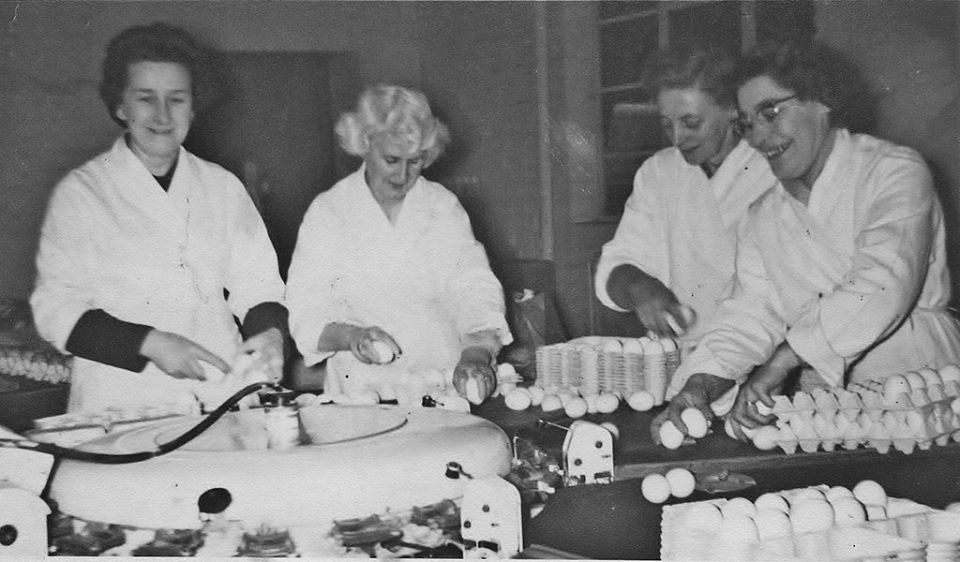
Egg packers at work in the New Lay egg packing plant. The factory was on Salhouse Road on the site now occupied by Wilco Fastfit the car part shops.
1967 Coprright Archant & https://www.localrecall.co.uk
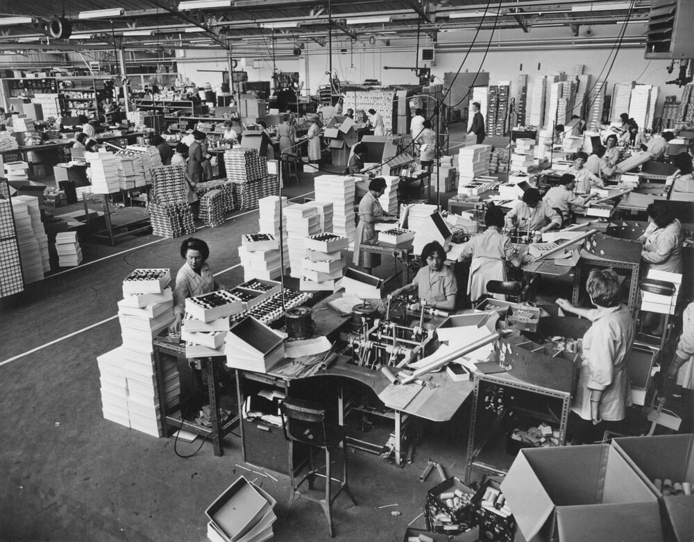
Zeller Plastics
This used to be one of the sites of Laurence & Scott. in 1991 it was CMB. The Zeller Plastik UK plant at Corby, Northants is closed and the entire operation is moved to the Norwich factory in 1996. Source It was U.G Key Plastics in the 60's.
This used to be one of the sites of Laurence & Scott. in 1991 it was CMB. The Zeller Plastik UK plant at Corby, Northants is closed and the entire operation is moved to the Norwich factory in 1996. Source It was U.G Key Plastics in the 60's.
Ardagh Group
This used to be be Tom Smith Cracker Factory that opened in1953 after moving from its other factory in London. Before 1935 the factory was a Caleys chocolate factory. They had a big fire in 1963 and if you look closely at the building near the roof you can see bits of black. Is this signs of the old fire? It closed in 1998.
Peter Kimpton has made a book all about crackers and alot of info about the cracker factory called Tom Smith's Christmas Crackers: An Illustrated History and you can read more information about the book and how to buy it here
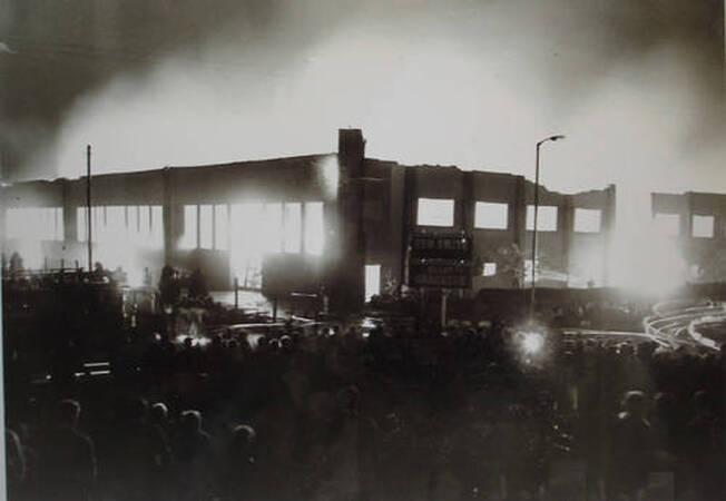
Picture of the Tom Smith Norwich factory fire in 1963.
Mousehold Light Railway
In the First World War, ammunition made at factories on Salhouse Road (Boulton & Paul) was transported on a light railway on a track through the heath and linking with the tramway before making its way to the Railway Station. Remnants of the rails could be seen until quite recent times in the Station area close to Thorpe Road.
Taken from here - http://www.heritagecity.org/research-centre/at-leisure-in-norwich/mousehold-heath.htm
Greenborough Farm (Smallpox Hospital)
On this map it shows Greenborough Farm and in brackets it said it was a smallpox Hosptial close to where the entrance is to Deloney Road but I have also read it was opposite where Fatsos is now and thats why there wasnt any houses built on that bit for ages even though there are some new houses there now. If anyone knows more please let me know. Has this hosptial got some link to the naming of Greenborough Road?
Cynthia Savory
My granddad was the caretaker at the smallpox hospital in1910. Greensborough Farm. The family lived in a cottage on Salhouse Road opposite the pub. Grandad was hit over the head by a tramp whilst he was putting paving slabs by the well so it was easier for nanny he collapsed and died. Caused by the head injury.
Nanny had to move out with three young children.
It is only in the last few years that the land where the cottage and well were that the land has been used for building.
Salhouse Road with The Florida Shoe Factory to the right (now Homebase)
