Sprowston History
  • Home
  • Sprowston Road Index
    • Roads A >
      • Aiken Close
      • Alford Grove
      • Allens Avenue
      • Amos Bacon Close
      • Aslake Close
      • Avian Way
      • Avocet Rise
    • Roads B >
      • Barkers Lane
      • Blackwell Avenue
      • Blenhiem Road
      • Blithemeadow Drive
      • Blue Boar Lane
      • Breck Road
    • Roads C >
      • Cannerby Lane
      • Cecil Gowing Court
      • Cere Road
      • Chartwell Road
      • Chenery Drive
      • Church Green
      • Colindeep Lane
      • Constitution Hill
      • Corbet Avenue
      • Cozens Hardy Road
      • Creance Road
      • Cromwell Road
    • Roads D >
      • Dixons Fold
      • Dovedales
    • Roads E >
      • Edwards Road
    • Roads F >
      • Falcoln Road West
    • Roads G >
      • Glenburn Avenue
      • Goshawk Mews
    • Roads H >
      • Hammond Way
      • Harrisons Drive
      • Holly Bank
      • Hornbeam Close
    • Roads L >
      • Lambert Road
      • Linacre Avenue
      • Lone Barn Road
      • Lusher's Loke
    • Roads M >
      • Mallard Way
      • Merlin Avenue
      • Millwrights Way
      • Mousehold Lane
    • Roads N >
      • Neville Road
      • North Walsham Road
    • Roads P >
      • Parkland Road
      • Pinetrees Road
    • Roads R >
      • Recreation Ground Road
      • Rosemary Road
      • Roundtree Way
    • Roads S >
      • Salhouse Road
      • School Lane
      • Shipfield
      • Sparhawk Avenue
      • Sprowston Road
      • St Georges Loke
      • Stonehouse Road
    • Roads T >
      • Tills Road
      • Tills Close
      • Tusting Close
    • Roads V >
      • Varvel Avenue
    • Roads W >
      • White Woman Lane
      • Wilks Farm Drive
      • Woodside Road
      • Wroxham Road
  • Timeline
  • Other Areas
    • Other Roads A >
      • Airedale Close
      • All Saints Green
      • Amsterdam Way, Hellesdon
      • Angel Road
      • Anglia Square
      • Aylsham Road, Banningham
      • Aylsham Road, Norwich
    • Other Roads B >
      • Bacton Road, North Walsham
      • Back Of The Inns, Norwich
      • Barnard Road, Bowthorpe
      • Barrack Street, Norwich
      • Baxter Court, Norwich
      • Beach Road, Hemsby
      • Bedford Street, Norwich
      • Bell Road, Norwich
      • Bessemer Road, Norwich
      • Ber Street
      • Bethel Street
      • Borrowdale Drive
      • Botolph Street, Norwich
      • Boundary Road, Hellesdon
      • Bowthorpe Road
      • Branford Road
      • Bridge Road, Potter Heigham
      • Britannia Rd
      • Bull Close
      • Burma Road, Old Catton
      • ​Bussey Road, Fiddlewood
      • Buxton Road, Spixworth
    • Other Roads C >
      • Cabbell Road, Cromer
      • California Road, California
      • Calvert Street, Norwich
      • Carrow Road
      • Castle Meadow, Norwich
      • Castle Gardens, Norwich
      • Castle Street, Norwich
      • Castle Street, Wroxham
      • Catton Chase
      • Catton Grove Road
      • Cambridge Street, Norwich
      • Chapel Road, Roughton
      • Chapelfield Road
      • Charing Cross
      • Church Street, Cromer
      • Church Plain, Great Yarmouth
      • Church Road, Hoveton
      • Church Road, Upton
      • Churchill Road, Great Yarmouth
      • Clancy Road
      • Coast Road, Bacton
      • Concorde Road
      • Connaught Road
      • Cowgate
      • Cozens Road
      • Cremorne Lane
      • Cromer Road, Hellesdon
      • Cromer Road, Mundesley
      • Cromer Road, West Runton
    • Other Roads D >
      • Dales Loke, Thorpe St Andrew
      • Daniels Road, Norwich
      • Davey Place
      • Denmark Road
      • Dereham Road, Norwich
      • Diamond Road, Norwich
      • Dog Lane, Horsford
      • Drayton High Road
      • Drayton High Street, Drayton
      • Drayton Road, Mile Cross
      • Duke Street, Norwich
      • Dussindale Drive
    • Other Roads E >
      • Eade Road
      • Earlham Road, Norwich
      • Edwards Street, Norwich
      • Esdelle Street, Norwich
      • Eversley Road
    • Other Roads F >
      • Farmers Avenue
      • Fifers Lane
      • Furze Road, Thorpe St Andrew
      • Fye Bridge Street
    • Other Roads G >
      • Garden Street, Cromer
      • Gentlemen's Walk, Norwich
      • Golding Place
      • Grammar School Road, North Walsham
      • Guardian Road
      • Guildhall Hill
      • Gurney Road
    • Other Roads H >
      • Halls Corner, Hevingham
      • Harvey Lane
      • Havers Road
      • Haymarket, Norwich
      • Heartsease Lane
      • Heigham Street
      • Hemming Way, Norwich
      • Henby Way, Thorpe St Andrew
      • High Street, Coltishall
      • Hillcrest Road
      • High Street, Cromer
      • High Street, Mundesley
      • Holt Road, Cromer
      • High Street, Overstrand
      • Hooker Road, Heartsease
      • Horning Road, Hoveton
      • Holt Road, Hellesdon
      • Holt Road, Horsford
      • Honeycombe Road, Salhouse
      • Hurricane Way
    • Other Roads I >
      • Ipswich Road
    • Other Roads J
    • Other Roads K >
      • Ketts Hill
      • King Street, Norwich
    • Other Roads L >
      • Laundry Lane, Thorpe St Andrew
      • Lodge Lane, Old Catton
      • London Street, Norwich
      • Lower Goat Lane
      • Lower Street, Salhouse
    • Other Roads M >
      • Magdalen Road
      • Magdalen Street
      • Manor Road, Newton St Faith
      • Market Gate Shopping Centre
      • Market Place, Aylsham
      • Market Place, Great Yarmouth
      • Market Street, North Walsham
      • Marine Parade, Great Yarmouth
      • Marryat Road
      • Middlebrook Way, Cromer
      • Mill Road, Cromer
      • Mill Road, Salhouse
      • Millenium Plain, Norwich
      • Millgate, Trowse
      • Mile Cross Lane
      • Mile Cross Road
      • Millers Lane
    • Other Roads N >
      • Nelson Street, Norwich
      • New Road, North Walsham
      • North Walsham Road, Beeston St Andrew
      • North Walsham Road, Trunch
      • Norwich Research Park
      • Norwich Road, Aylsham
      • Norwich Road, Horsham St Faith
      • Norwich Road, Hoveton
      • Norwich Road, Marsham
      • Newport Road, Newport
      • Norwich Road, North Walsham
      • Northumberland Street, Norwich
      • Norwich Road, Wroxham
    • Other Roads O >
      • Oak Street, Norwich
      • Old Road, Acle
      • Old Library Mews
      • Orford Hill, Norwich
      • Orford Place, Norwich
    • Other Roads P >
      • Park Avenue, Scottow
      • Philadelphia Lane
      • Plumstead Road, Norwich
      • Plumstead Road, Thorpe End
      • Plumstead Road East
      • Pottergate
      • Pound Lane, Thorpe St Andrew
      • Prince Of Wales Road, Norwich
      • Priory Plain, Great Yarmouth
    • Other Roads Q >
      • Quebec Road, Norwich
      • Queens Road
    • Other Roads R >
      • Rampant Horse Street Norwich
      • Regent Road, Great Yarmouth
      • Reepham Road, Hellesdon
      • Riverside Centre, Hoveton
      • Riverside Road, Norwich
      • Rosary Road
      • Rose Lane, Norwich
      • Roundtree Close
      • Rouen Road
      • Runton Road, Cromer
    • Other Roads S >
      • Salhouse Road, Rackheath
      • Sae View Road, Hemsby
      • Silver Street, Norwich
      • South Hill Road, Thorpe St Andrew
      • South Market Road, Great Yarmouth
      • Southwell Road, Horsham St Faith
      • Spar Road, Norwich
      • Spixworth Road, Old Catton
      • St Augustines Street
      • St Benedict's Street, Norwich
      • St Faiths Road, Old Catton
      • St Giles Street
      • St Leonards Road
      • St Nicholas Road, Great Yarmouth
      • St Stephens Road
      • St Stephens Street
      • St Thomas Road, Hemsby
      • Stalham Road, Hoveton
      • Station Road, Hoveton
      • Station Road, West Runton
      • Surrey Street, Norwich
      • Swan Lane
    • Other Roads T >
      • The Green, Martham
      • The Paddocks, Old Catton
      • The Street, Brundall
      • The Street, Hemsby
      • Thorpe Avenue
      • Thorpe Road, Norwich
      • Thunder Lane, Thorpe St Andrew
      • Timberhill
      • Tombland
    • Other Roads U >
      • Unthank Road
    • Other Roads V >
      • Vulcan Road North / South
    • Other Roads W >
      • Waterloo Road
      • Watling Road, Heartsease
      • West End Street, Norwich
      • West Street, Cromer
      • Westlegate, Norwich
      • Westwick Street, Norwich
      • Weston Hall Road
      • Whiffler Road
      • White Lion Street, Norwich
      • Woodcock Road
      • Woodham Leas
      • Wroxham Road, Rackheath
    • Other Roads X
    • Other Roads Y >
      • Yarmouth Road, Caister On Sea
      • Yarmouth Road, North Walsham
      • Yarrmouth Road, Thorpe St Andrew
    • Other Roads Z
  • Links & Local Books
  • Credits
  • Contact Me
  • Salhouse Road
  • Hemsby - List of old shops and arcades
  • Egyptian Road
  • Lollard Road
  • Station Road, Coltishall
  • Whimpwell Green, Happisburgh
  • North Walsham Road, Scottow

All Saints Green

2-8 All Saints Green - The Pig And Whistle Pub
Used the be The Tuns which was demolished and rebuilt and Chandlers. and Imagine.

Join the Chandlers Facebook page here - ​https://www.facebook.com/Old-Chandlers-Pics-Page-410776009032383/?__tn__=-UC*F


Picture
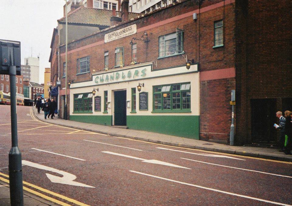
Credit: Old Chandlers Pics Page on Fscebook
Picture
10 All Saints Green
Used to be Charles Cubitt Antiques in 1973.
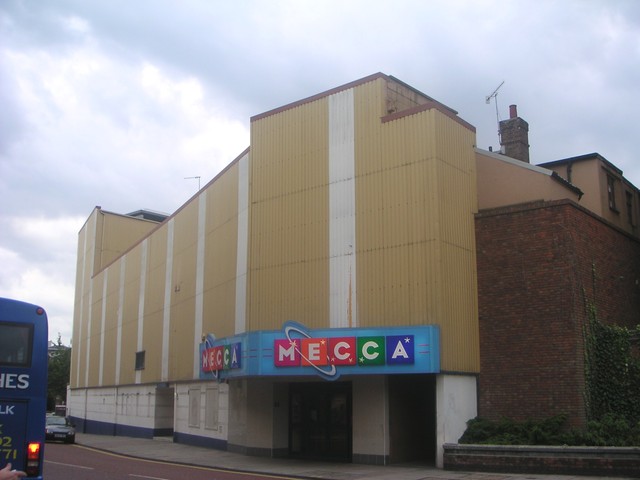
​30 All Saints Green - Pablo Fanque House

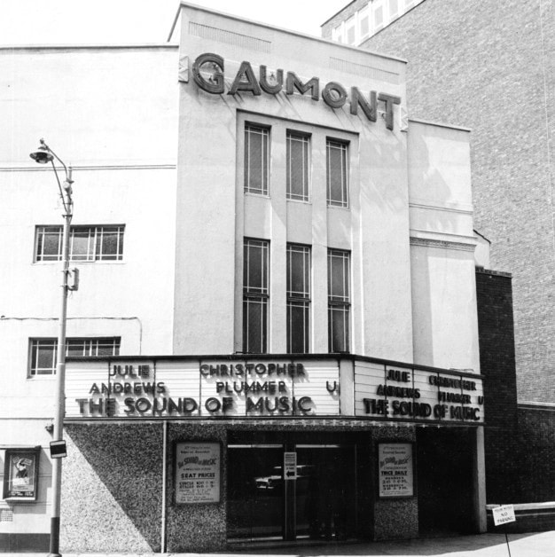
​It opened as the Carlton Cinema in 1932, was enlarged and reopened, with double the number of seats – now 1,920, only two years later in 1934 when it was operated by Lou Morris. Two years after that it was taken over by County Cinemas and then by Odeon Theatres Ltd.

After the city’s Gaumont cinema was closed and demolished in 1959, Rank rebranded the Carlton Cinema with the Gaumont name which lasted until closure in 1973.
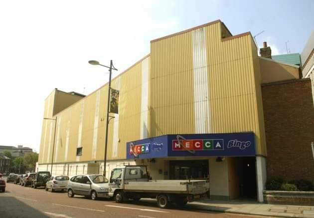
It reopened as a Top Rank Bingo Club immediately and remained a bingo club until closing as a Mecca Bingo Club on 18th April 2011 when serious structural defects were found in the building. The building was demolished between June and August 2014. In 1963 The Rolling Stones played there.

From here - http://cinematreasures.org/theaters/6326/

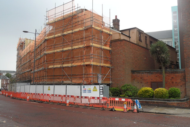
It was demolished and a new building was built called Pablo Fanque House and is student acoomodation. The developers behind the 13-storey student accommodation being built in All Saints Green have announced the complex will be named Pablo Fanque House.

Fanque was born William Darby in Norwich in 1810 and lived in Ber Street, just around the corner from Alumno Developments’ new tower.

As a young man, Fanque joined a circus where he trained and handled horses. But he was also skilled as a tightrope walker and trapeze artist.

He struck out on his own in the early 1840s, becoming the first black circus owner in the country. His circus primarily performed in the north of England.​
Picture
Copyright Archant thanks to Local Recall Project
Picture
Picture
Credit - https://www.localrecall.co.uk/ from Archant where you can find lots of old stories and pictures from the EDP archive.
Picture
https://www.localrecall.co.uk/ Copyright Archant


Powered by Create your own unique website with customizable templates.