Home
Sprowston Road Index
Roads A
>
Aiken Close
Alford Grove
Allens Avenue
Amos Bacon Close
Aslake Close
Atlantic Avenue
Avian Way
Avocet Rise
Roads B
>
Barkers Lane
Blackwell Avenue
Blenhiem Road
Blithemeadow Drive
Blue Boar Lane
Breck Road
Roads C
>
Cannerby Lane
Cecil Gowing Court
Cere Road
Chartwell Road
Chenery Drive
Church Green
Colindeep Lane
Constitution Hill
Corbet Avenue
Cozens Hardy Road
Creance Road
Cromwell Road
Roads D
>
Dixons Fold
Dovedales
Roads E
>
Edwards Road
Roads F
>
Falcoln Road West
Roads G
>
Glenburn Avenue
Goshawk Mews
Roads H
>
Hammond Way
Harrisons Drive
Holly Bank
Hornbeam Close
Roads L
>
Lambert Road
Linacre Avenue
Lone Barn Road
Lusher's Loke
Roads M
>
Mallard Way
Merlin Avenue
Millwrights Way
Mousehold Lane
Roads N
>
Neville Road
North Walsham Road
Roads P
>
Parkland Road
Pinetrees Road
Roads R
>
Recreation Ground Road
Rosemary Road
Roundtree Way
Roads S
>
Salhouse Road
School Lane
Shipfield
Sparhawk Avenue
Sprowston Road
St Georges Loke
Stonehouse Road
Roads T
>
Tills Road
Tills Close
Tusting Close
Roads V
>
Varvel Avenue
Roads W
>
White Woman Lane
Wilks Farm Drive
Woodside Road
Wroxham Road
Timeline
Other Areas
Other Roads A
>
Agricultural Hall Plain
Airedale Close
All Saints Green
Amsterdam Way, Hellesdon
Anchor Street, Norwich
Angel Road
Anglia Square
Ardney Rise
Aylsham Road, Banningham
Aylsham Road, Norwich
Other Roads B
>
Bacton Road, North Walsham
Back Of The Inns, Norwich
Barber Place
Barnard Road, Bowthorpe
Barrack Street, Norwich
Baxter Court, Norwich
Beach Road, Hemsby
Beach Road, Mundesley
Beach Road, Sheringham
Bedford Street, Norwich
Bell Road, Norwich
Bessemer Road, Norwich
Beeston Road, Sheringham
Ber Street
Bethel Street
Bishop Bridge Road
Borrowdale Drive
Botolph Street, Norwich
Boundary Road, Hellesdon
Bowers Avenue
Bowthorpe Road
Branford Road
Branford Road, Caister-on-Sea
Brewery Road, Trunch
Bridge Road, Potter Heigham
Britannia Rd
Bull Close
Bull Close Road
Burma Road, Old Catton
Bussey Road, Fiddlewood
Buxton Road, Spixworth
Other Roads C
>
Cabbell Road, Cromer
Cadogan Road, Cromer
California Road, California
Calvert Street, Norwich
Cambridge Street, Norwich
Carrow Hill
Carrow Road
Castle Meadow, Norwich
Castle Gardens, Norwich
Castle Street, Norwich
Castle Street, Wroxham
Cattle Market Street
Catton Chase
Catton Grove Road
Cedar Road
Chapel Road, Roughton
Chapelfield Road
Charing Cross
Church Street, Cromer
Church Street, Old Catton
Church Plain, Great Yarmouth
Church Road, Bacton
Church Road, Hoveton
Church Road, Upton
Church Street, Sheringham
Churchill Road, Great Yarmouth
Clancy Road
Coast Road, Bacton
Concorde Road
Connaught Road
Cowgate
Cozens Road
Cremorne Lane
Cromer Road, Aylsham
Cromer Road, Hellesdon
Cromer Road, Hevingham
Cromer Road, Mundesley
Cromer Road, Sheringham
Cromer Road, West Runton
Cucumber Lane, Brundall
Other Roads D
>
Dales Loke, Thorpe St Andrew
Daniels Road, Norwich
Davey Place
Denmark Road
Dereham Road, Norwich
Distillery Street
Diamond Road, Norwich
Dog Lane, Horsford
Dove Street, Norwich
Drayton High Road
Drayton High Street, Drayton
Drayton Road, Mile Cross
Duke Street, Norwich
Dussindale Drive
Other Roads E
>
Eade Road
Earlham Road, Norwich
Edwards Street, Norwich
Egyptian Road
Esdelle Street, Norwich
Eversley Road
Exchange Street, Norwich
Other Roads F
>
Farmers Avenue
Fifers Lane
Fishers Lane, Norwich
Furze Road, Thorpe St Andrew
Fye Bridge Street
Other Roads G
>
Garden Street, Cromer
Garrick Green, Norwich
Gentlemen's Walk, Norwich
Gertrude Road, Norwich
Golden Ball Street
Golding Place
Gordon Avenue
Grammar School Road, North Walsham
Grapes Hill
Greenborough Road
Guardian Road
Guildhall Hill
Gurney Road
Other Roads H
>
Halls Corner, Hevingham
Harvey Lane
Havers Road
Haymarket, Norwich
Heath Road, Norwich
Heartsease Lane
Heigham Street
Hemming Way, Norwich
Henby Way, Thorpe St Andrew
High Street, Coltishall
Hillcrest Road
High Street, Cromer
High Street, Mundesley
High Street, Overstrand
High Street, Stalham
Holt Road, Cromer
Holt Road, Sheringham
Hooker Road, Heartsease
Horning Road, Hoveton
Holt Road, Hellesdon
Holt Road, Horsford
Honeycombe Road, Salhouse
Hurricane Way
Other Roads I
>
Ingham Road, Lessingham
Ipswich Road
Other Roads J
>
Jolly Gardeners Court, Norwich
Other Roads K
>
Kerrison Road
Ketts Hill
King Street, Norwich
Kingsley Road, Norwich
Other Roads L
>
Ladysmith Road, Norwich
Larkman Lane
Lawrence Street, Norwich
Lawson Road, Norwich
Laundry Lane, Thorpe St Andrew
Laundry Loke, North Walsham
Leopold Road
Lodge Lane, Old Catton
Lollard Road
London Street, Norwich
Lovett Close
Low Road, Norwich
Lower Goat Lane
Lower Street, Horning
Lower Street, Salhouse
Other Roads M
>
Magdalen Road
Magdalen Street
Magpie Road, Norwich
Manor Road, Newton St Faith
Market Gate Shopping Centre
Market Place, Aylsham
Market Place, Great Yarmouth
Market Street, North Walsham
Marine Parade, Great Yarmouth
Marlborough Road
Marryat Road
Middlebrook Way, Cromer
Mill Road, Cromer
Mill Road, Salhouse
Millenium Plain, Norwich
Millgate, Trowse
Mile Cross Lane
Mile Cross Road
Millers Lane
Mousehold Street, Norwich
Mundesley Road, North Walsham
Mundesley Road, Trimingham
Other Roads N
>
Nelson Street, Norwich
New Road, North Walsham
New Street, Cromer
North Walsham Road, Beeston St Andrew
North Walsham Road, Scottow
North Walsham Road, Trunch
Norwich Research Park
Norwich Road, Aylsham
Norwich Road, Horsham St Faith
>
Norwich Road, Horstead
Norwich Road, Hoveton
Norwich Road, Little Plumstead
Norwich Road, Marsham
Newport Road, Newport
Norwich Road, North Walsham
Norwich Road, Wroxham
Northumberland Street, Norwich
Other Roads O
>
Oak Street, Norwich
Old Church Road, Frettenham
Old Road, Acle
Old Laundry Court, Norwich
Old Library Mews
Old Market Road, Stalham
Old Palace Road, Norwich
Old Post Office Court
Orford Hill, Norwich
Orford Place, Norwich
Ormesby Road, Caister-on-Sea
Other Roads P
>
Paddock Street. Norwich
Park Avenue, Scottow
Patterson Road
Peacock Street, Norwich
Peckover Road
Philadelphia Lane
Pier Gardens Gorleston-on-Sea, Great Yarmouth,
Pitt Street
Plumstead Road, Norwich
Plumstead Road, Thorpe End
Plumstead Road East
Pottergate
Post Office Close, South Walsham
Post Office Road, Frettenham
Pound Lane, Thorpe St Andrew
Prince Of Wales Road, Norwich
Priory Plain, Great Yarmouth
Other Roads Q
>
Quebec Road, Norwich
Queens Road
Queens Street, Norwich
Other Roads R
>
Railway Street, Norwich
Rampant Horse Street Norwich
Red Lion Street, Aylsham
Red Lion Street, Norwich
Regent Road, Great Yarmouth
Regent Street, Great Yarmouth
Reepham Road, Hellesdon
Ring Road, NR7
Riverside Centre, Hoveton
Riverside Road, Norwich
Rosary Road
Rosebery Road, Norwich
Rose Lane, Norwich
Royal Arcade, Norwich
Roundtree Close
Rouen Road, Norwich
Rouen Road
Runton Road, Cromer
Russell Avenue, Sprowston
Other Roads S
>
Sale Road, Norwich
Salhouse Road, Rackheath
Sae View Road, Hemsby
Shortthorn Road, Stratton Strawless
Silver Road, Norwich
Silver Street, Norwich
South Hill Road, Thorpe St Andrew
South Market Road, Great Yarmouth
Southwell Road, Horsham St Faith
Spar Road, Norwich
Spencer Street, Norwich
Spinney Road
Spixworth Road, Old Catton
St Augustines Street
St Benedict's Street, Norwich
St Faiths Road, Old Catton
St Giles Street
St Leonards Road
St Matthews Road, Norwich
St Nicholas Road, Great Yarmouth
St Stephens Road
St Stephens Street
St Thomas Road, Hemsby
Starling Road, Norwich
Station Road, Coltishall
Station Road, Cromer
Stalham Road, Hoveton
Stalham Road, Wayford
Station Road, Hoveton
Station Road, West Runton
Surrey Street, Norwich
Swan Lane
Other Roads T
>
The Esplanade, Sheringham
The Gangway, Cromer
The Green, Martham
The Paddocks, Old Catton
The Street, Acle
The Street, Brundall
The Street, Hemsby
The Street, Honing
The Street, Neatishead
The Street, Sea Palling
The Street, South Walsham
The Street, Swafield
Thorpe Avenue
Thorpe Road, Norwich
Thunder Lane, Thorpe St Andrew
Timberhill
Tombland
Trunch Road., Mundesley
Other Roads U
>
Unthank Road
Upper St Giles Street
Other Roads V
>
Vicarage Street, North Walsham
Vincent Road, Norwich
Vulcan Road North / South
Other Roads W
>
Waterloo Road
Watling Road, Heartsease
Waxham Road, Sea Palling
West End Street, Norwich
West Pottergate
West Street, Cromer
Westlegate, Norwich
Westwick Street, Norwich
Weston Hall Road
Weybourne Road, Sheringham
Wherry Road, Norwich
Whiffler Road
Whimpwell Green, Happisburgh
White Lion Street, Norwich
Wilson Road, Norwich
Wodehouse Street, Norwich
Woodcock Road
Woodham Leas
Woodland Drive, Old Catton
Wroxham Road, Rackheath
Other Roads X
Other Roads Y
>
Yarmouth Road, Caister On Sea
Yarmouth Road, North Walsham
Yarmouth Road, Stalham
Yarrmouth Road, Thorpe St Andrew
Other Roads Z
Links & Local Books
Credits
Contact Me
Salhouse Road
Hemsby - List of old shops and arcades
High
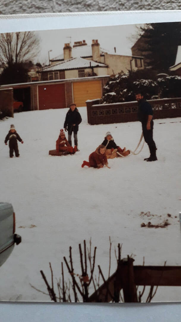
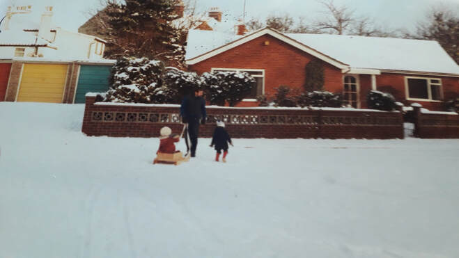
Dovedales
Brickyard
There used to be an old brickworks in this area.
Thanks to Marisa Woodhouse who sent us these two photos from 1984 in Dovedales.